
Entegrasyonlar
GBIF yakındaki türler
The app queries the published GBIF occurrence record around your current position and returns the taxa that have been recorded there, arranged in a taxonomic tree you can expand level by level and download from. It shows which groups are represented, how many distinct species (or higher taxa, at the detail level you choose) each group holds in the published record, and which names belong to those groups, before you start your own recording.
Nasıl açılır
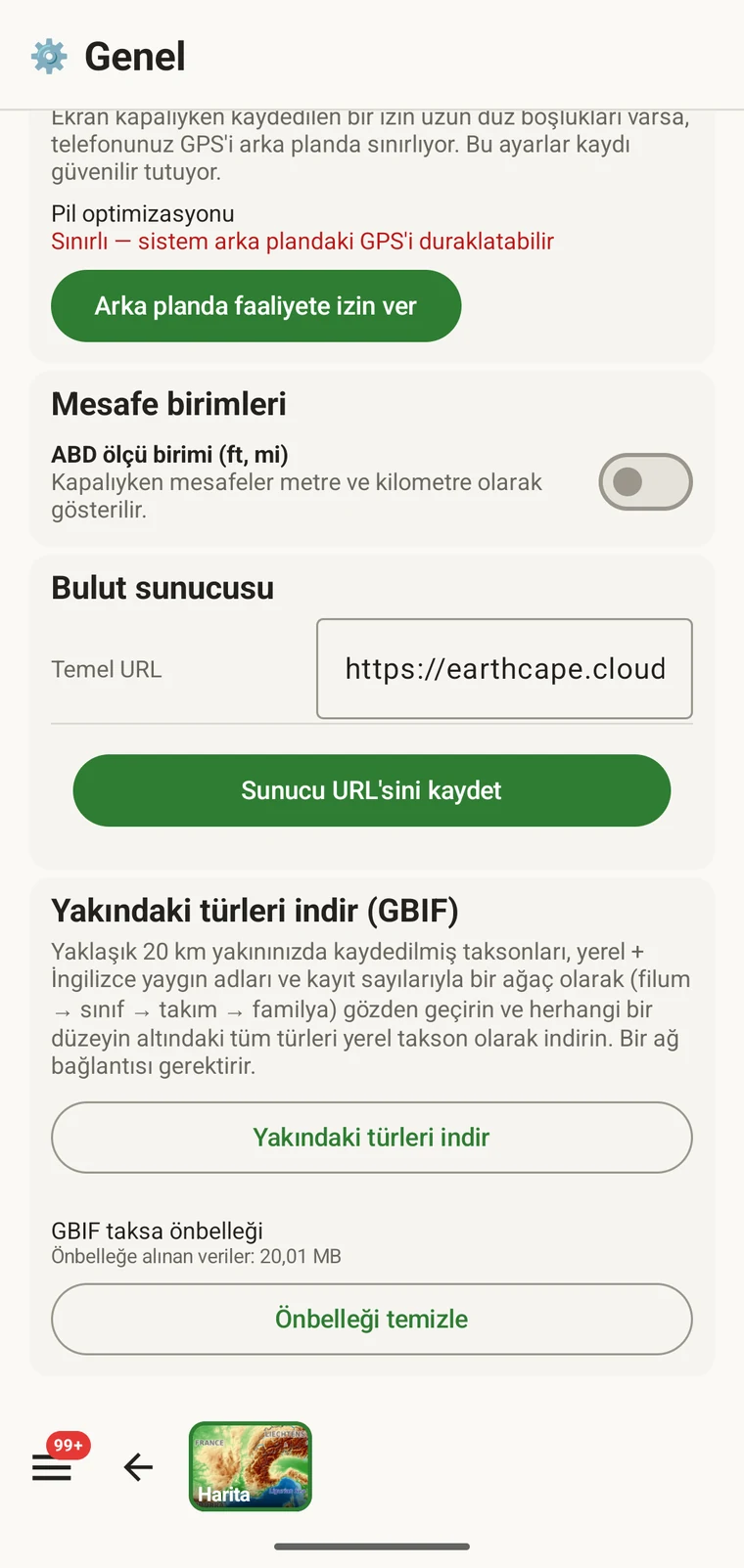
The entry point is the Download nearby species (GBIF) card under Menu → Admin → General; it is also offered during first-run setup. Scroll to the card and tap Download nearby species. The query runs against the live GBIF API, so you need a connection. Run it before you leave for the field, not once you have lost signal.
Sorgunun döndürdükleri
The query looks at GBIF occurrence records within 20 km of your current position and groups them by phylum, giving for each phylum the number of distinct taxa at the chosen detail level (species by default). The sheet shows the top-level summary once Get data has run.
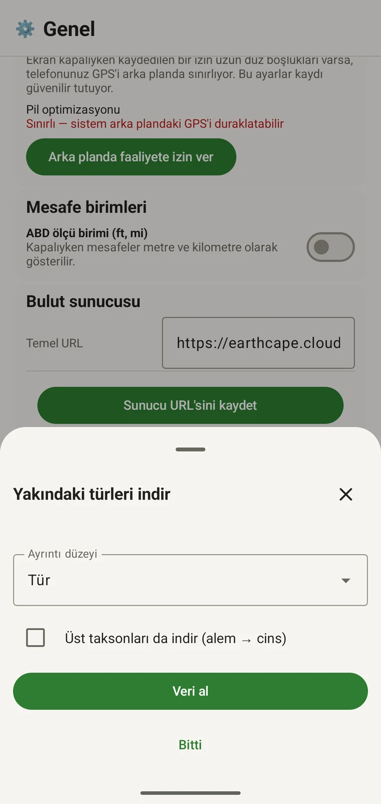
On opening, the sheet shows two controls and two buttons:
- Detail level (Phylum, Class, Order, Family or Species; Species is the default) — sets how far down the taxonomy the download goes when you tick a group.
- Also download parent taxa (kingdom → genus) checkbox — off by default; covered in its own section below.
- Get data — takes a GPS fix and loads the taxonomic tree for the area. Nothing is downloaded yet.
- Tamamlandı — sayfayı kapatır.
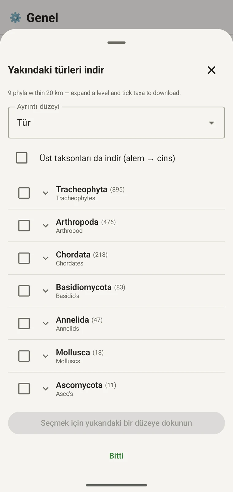
Once the tree has loaded the header reads, for example, "9 phyla within 20 km — expand a level and tick taxa to download.", a Select all row appears above the tree, and a Download N selected button replaces Get data.
Aşağıdaki örnek, dağlık arazide yapılan bir arazi çalışmasından alınmıştır. Kendi alanınız kendi değerlerini döndürecektir.
| Filum | Species within 20 km |
|---|---|
| Tracheophyta | 895 |
| Arthropoda | 476 |
| Chordata | 218 |
| Basidiomycota | 83 |
| Annelida | 47 |
| Mollusca | 18 |
| Ascomycota | 11 |
Ayrıntıya inme
Tap a phylum to expand it to its constituent classes, and tap a class to expand to orders. At each level the number in brackets is the count of distinct taxa at the chosen detail level recorded under that group within the search radius. A count shown as 1,000+ has hit the query cap.
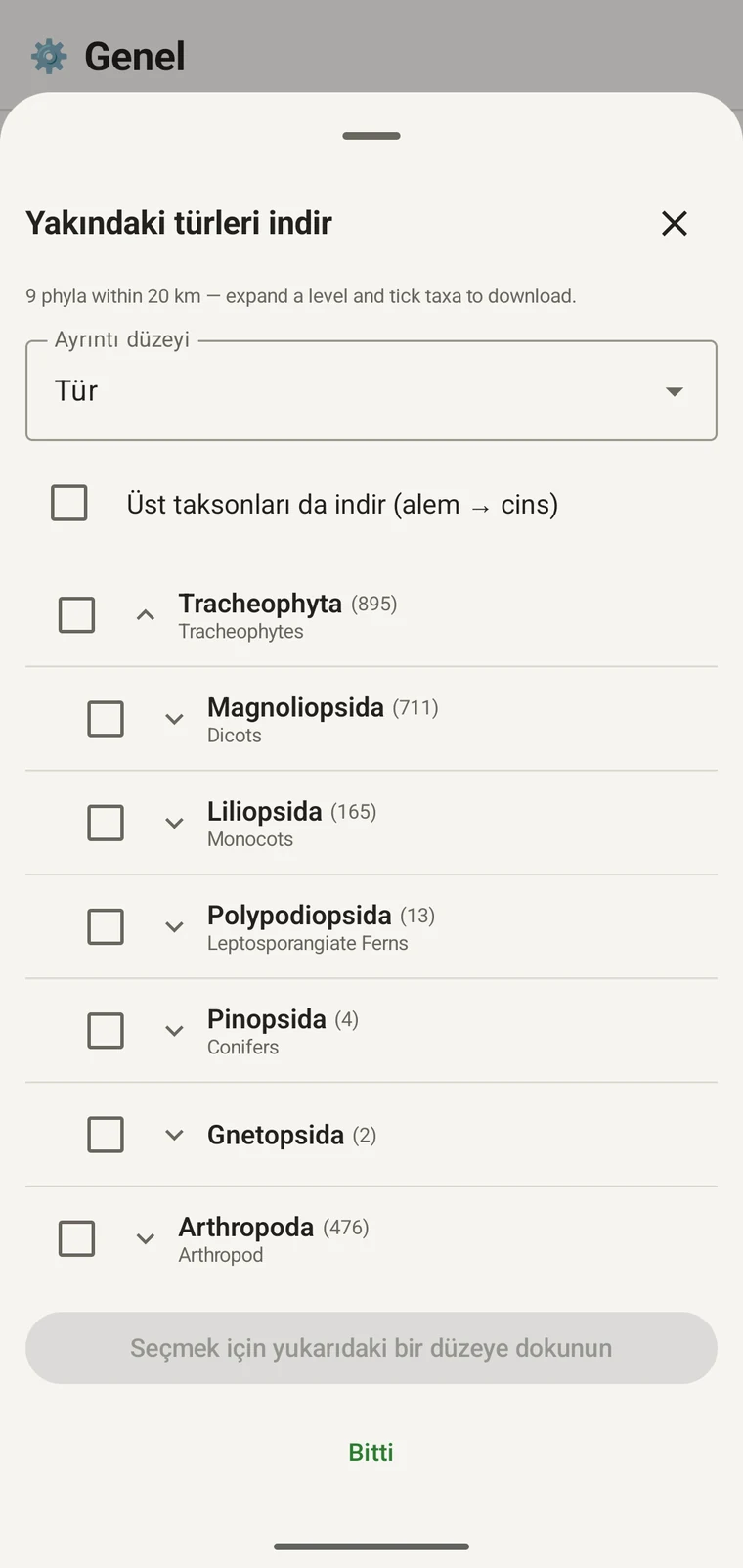
Aynı örneği sürdürürsek: Tracheophyta, Magnoliopsida 711, Liliopsida 165, Polypodiopsida 13, Pinopsida 4, Gnetopsida 2 olarak genişler. Magnoliopsida genişletildiğinde Asterales 115, Lamiales 100, Fabales 93, Rosales 56, Caryophyllales 49 elde edilir; her biri yerel adıyla gösterilir.
The counts are numbers of distinct taxa in the published record, not record totals and not abundance estimates. A high count means many taxa in that group have been recorded and published for this area; a low count means the group is either genuinely species-poor here or simply under-surveyed and under-published. The distinction matters when you use the figures to plan work — see the section on survey planning below.
Ayrıntı düzeyi ve üst taksonlar
The Detail level control sets the rank down to which taxa are downloaded when you tick a group. At Species, the download includes all species in GBIF's record for that group within the radius. If you are working at a coarser resolution — mapping genera only, for example — you can set the detail level to Family, Order, Class or Phylum to reduce the volume of names brought onto the device.
The Also download parent taxa (kingdom → genus) checkbox controls whether the higher ranks are fetched alongside the species. It is off by default; tick it in almost every case. Without it, the species names arrive on the device as orphans: the taxonomy held locally has no genus, family or order to attach them to, so they cannot be browsed by higher taxon and any rollup by group in your own data will not resolve correctly. Leave it off only if storage is genuinely tight and you intend to work entirely at species level with no hierarchical browsing.
Taksonları cihaza indirme
Nothing is pre-loaded onto the device for any particular site. The GBIF query populates the local taxonomy with GBIF Backbone names known to occur nearby, so when you record an observation you are picking from taxa that have actually been found at the site, rather than searching the full global list — and those names stay on the device once they are downloaded.
- Ayrıntı düzeyi ayarını kayıt gereksinimlerinize uyan kategoriye getirin. Varsayılan, Türler'dir.
- Tap Get data to load the tree for your position.
- Bir filumu genişletmek için ona dokunun, ardından istediğiniz sınıfa veya takıma kadar genişletmeyi sürdürün.
- Kaydedeceğiniz her grubun yanındaki onay kutusunu işaretleyin. Herhangi bir kategoride işaretleme yapabilirsiniz — bir sınıfı işaretlemek, o sınıfın içerdiği tüm taksonları belirlediğiniz ayrıntı düzeyine kadar indirir.
- Tick Also download parent taxa unless storage is genuinely tight.
- Tap Download N selected. The app fetches the ticked taxa from GBIF and writes them to the local database in the background; a notification shows progress and you can close the sheet meanwhile.
- Sayfayı kapatmak için Tamamlandı öğesine dokunun.
İndirilen adlar, Gözlem kaydetme sırasında gözlem girerken çevrimdışı olarak aranabilir. Küresel taksonominin tamamına karşı ezberden yazmak yerine, yörede bulunduğu bilinen adlar arasından seçim yaparsınız.
Arazi çalışması planlamak için kullanma
Bir arazi sezonundan önce sorguyu hedeflediğiniz alan üzerinde çalıştırın ve herhangi bir şey indirmeden önce filum düzeyindeki sayıları okuyun. Sayıların dağılımı, o alana ilişkin yayımlanmış kayıtta hangi grupların iyi temsil edildiğini, hangilerinin ise neredeyse hiç bulunmadığını gösterir.
A phylum with a handful of taxa is either genuinely absent from the site or under-surveyed and under-published there. Both cases are useful to know before a trip: genuine absence tells you where not to spend effort, and a thin published record for a group you expect to be present identifies a gap you can target.
Yalnızca belirli bir gezide etkin biçimde kaydedeceğiniz gruplar için takson indirin. Tek bir filum üzerinde çalışıyorsanız ağacın tamamını cihaza yüklemenin bir yararı yoktur; indirme, sahip olmayabileceğiniz zamanı ve bağlantı bant genişliğini tüketir.
Sınırlar
Sorgu, GBIF API'sine canlı bir bağlantı gerektirir. Çevrimdışı çalışamaz; öngörülen iş akışının, bağlantının bulunduğu bir yerden ayrılmadan önce sorguyu çalıştırmak olmasının nedeni budur.
The search radius is 20 km around your current position. This is fixed by the query; there is no radius control in the app.
Sayılar, GBIF'e yayımlanmış olanı yansıtır. Kapsam, bölgeler arasında ve taksonomik gruplar arasında eşit değildir: Batı Avrupa'daki omurgalılar genellikle iyi temsil edilir; Orta Asya'daki omurgasızlar ve mantarlar edilmez. Düşük bir sayı, o grup ve konum birleşimi için yayımlanmış kayda ilişkin bir ifadedir; alanın kendisine ilişkin doğrudan bir ifade değildir. Değerleri bunu göz önünde bulundurarak yorumlayın.
Uygulamadan GBIF'e yayımlama yoktur. Entegrasyon salt okunurdur: mevcut kayıtları sorgular ve takson adlarını indirirsiniz. Kendi verilerinizi GBIF'e katmak için uygulamadan bir Darwin Core Archive veya GBIF DwC-DP dosyası dışa aktarır ve bunu standart GBIF yolundan teslim edersiniz — kullanılabilir dosya biçimleri için bkz. Dışa aktarma biçimleri.