
Integracje
Gatunki w pobliżu z GBIF
The app queries the published GBIF occurrence record around your current position and returns the taxa that have been recorded there, arranged in a taxonomic tree you can expand level by level and download from. It shows which groups are represented, how many distinct species (or higher taxa, at the detail level you choose) each group holds in the published record, and which names belong to those groups, before you start your own recording.
Otwieranie
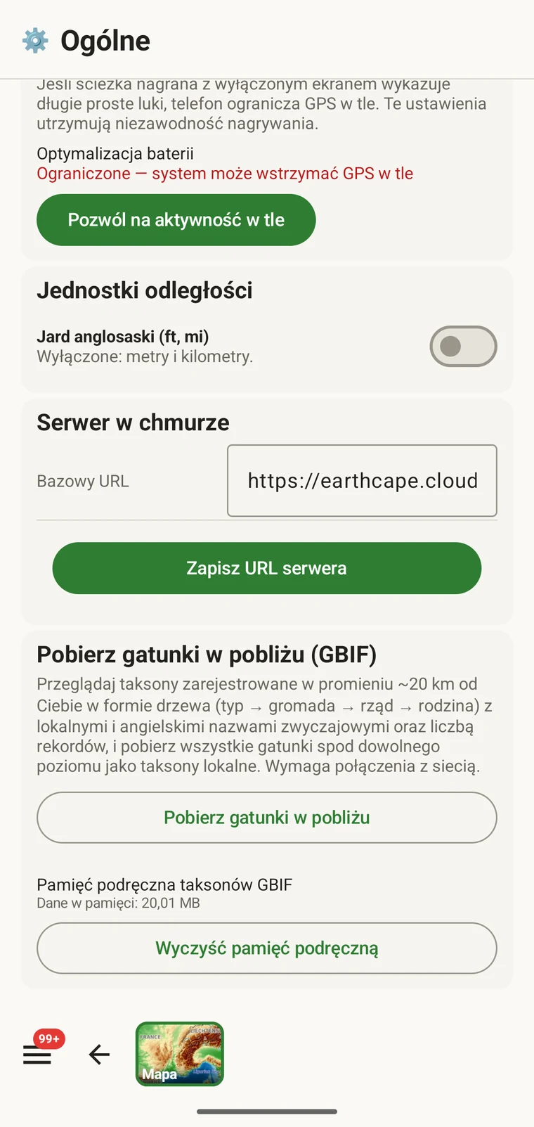
The entry point is the Download nearby species (GBIF) card under Menu → Admin → General; it is also offered during first-run setup. Scroll to the card and tap Download nearby species. The query runs against the live GBIF API, so you need a connection. Run it before you leave for the field, not once you have lost signal.
Co zwraca zapytanie
The query looks at GBIF occurrence records within 20 km of your current position and groups them by phylum, giving for each phylum the number of distinct taxa at the chosen detail level (species by default). The sheet shows the top-level summary once Get data has run.
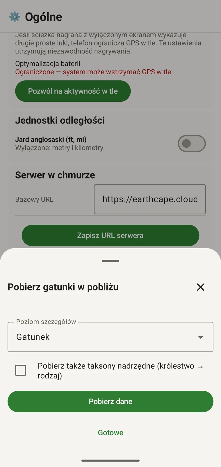
On opening, the sheet shows two controls and two buttons:
- Detail level (Phylum, Class, Order, Family or Species; Species is the default) — sets how far down the taxonomy the download goes when you tick a group.
- Also download parent taxa (kingdom → genus) checkbox — off by default; covered in its own section below.
- Get data — takes a GPS fix and loads the taxonomic tree for the area. Nothing is downloaded yet.
- Gotowe — zamyka arkusz.
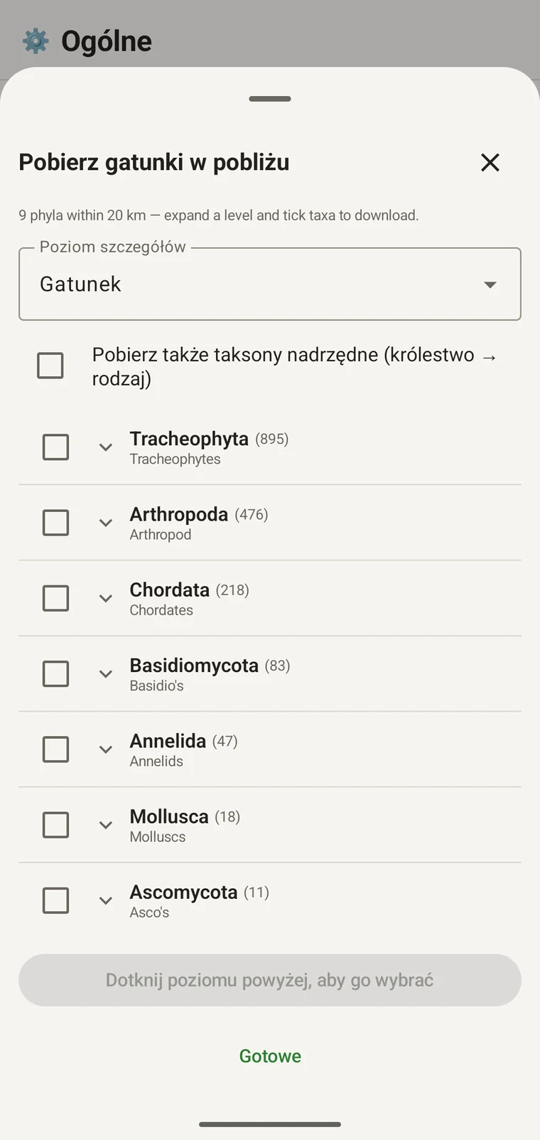
Once the tree has loaded the header reads, for example, "9 phyla within 20 km — expand a level and tick taxa to download.", a Select all row appears above the tree, and a Download N selected button replaces Get data.
Poniższy przykład pochodzi z badania prowadzonego w górach. Własne stanowisko zwróci własne wartości.
| Typ | Species within 20 km |
|---|---|
| Tracheophyta | 895 |
| Arthropoda | 476 |
| Chordata | 218 |
| Basidiomycota | 83 |
| Annelida | 47 |
| Mollusca | 18 |
| Ascomycota | 11 |
Schodzenie w głąb
Tap a phylum to expand it to its constituent classes, and tap a class to expand to orders. At each level the number in brackets is the count of distinct taxa at the chosen detail level recorded under that group within the search radius. A count shown as 1,000+ has hit the query cap.
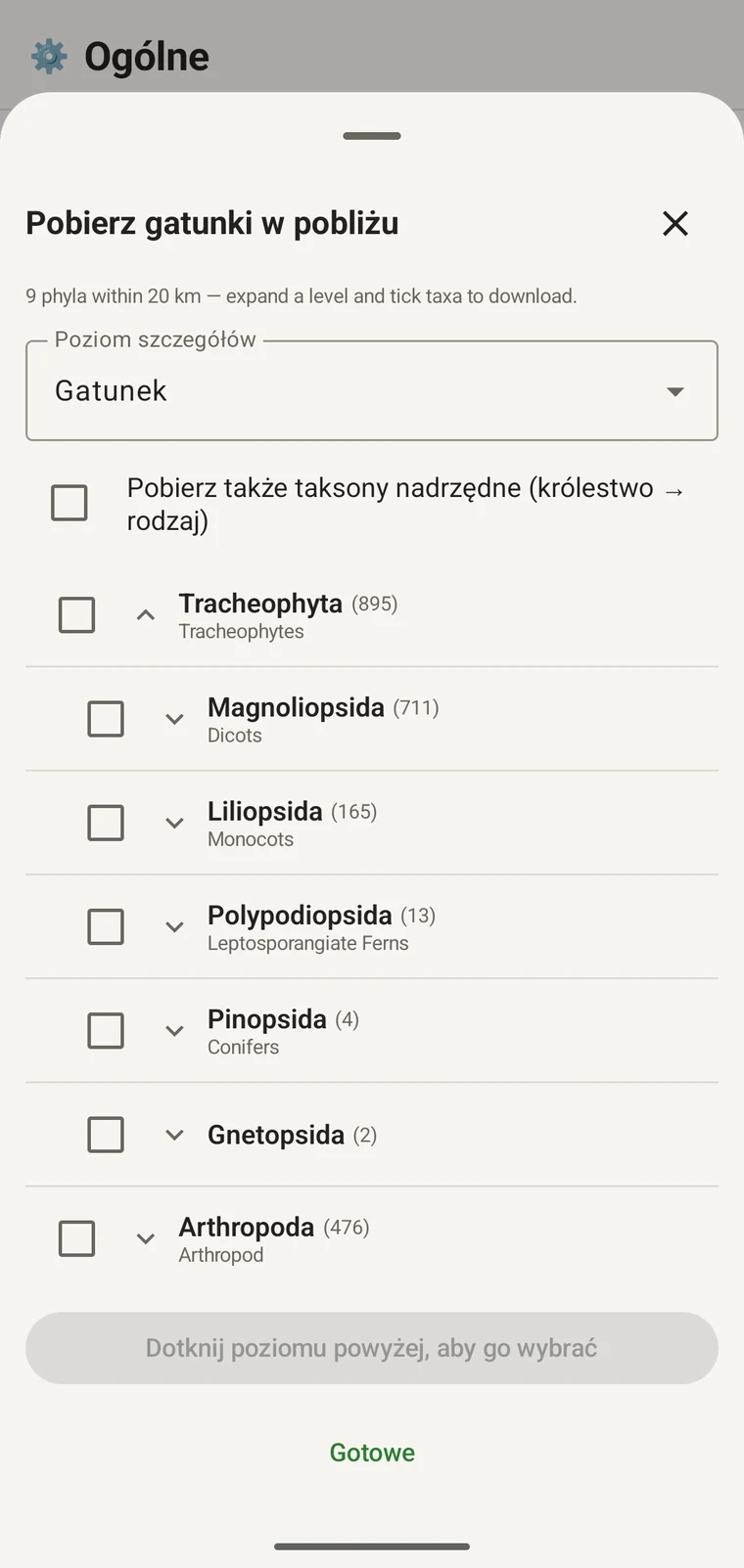
Kontynuacja tego samego przykładu: Tracheophyta rozwija się do Magnoliopsida 711, Liliopsida 165, Polypodiopsida 13, Pinopsida 4, Gnetopsida 2. Rozwinięcie Magnoliopsida daje Asterales 115, Lamiales 100, Fabales 93, Rosales 56, Caryophyllales 49, każdy pokazany ze swoją nazwą zwyczajową.
The counts are numbers of distinct taxa in the published record, not record totals and not abundance estimates. A high count means many taxa in that group have been recorded and published for this area; a low count means the group is either genuinely species-poor here or simply under-surveyed and under-published. The distinction matters when you use the figures to plan work — see the section on survey planning below.
Poziom szczegółów i taksony nadrzędne
The Detail level control sets the rank down to which taxa are downloaded when you tick a group. At Species, the download includes all species in GBIF's record for that group within the radius. If you are working at a coarser resolution — mapping genera only, for example — you can set the detail level to Family, Order, Class or Phylum to reduce the volume of names brought onto the device.
The Also download parent taxa (kingdom → genus) checkbox controls whether the higher ranks are fetched alongside the species. It is off by default; tick it in almost every case. Without it, the species names arrive on the device as orphans: the taxonomy held locally has no genus, family or order to attach them to, so they cannot be browsed by higher taxon and any rollup by group in your own data will not resolve correctly. Leave it off only if storage is genuinely tight and you intend to work entirely at species level with no hierarchical browsing.
Pobieranie taksonów na urządzenie
Nothing is pre-loaded onto the device for any particular site. The GBIF query populates the local taxonomy with GBIF Backbone names known to occur nearby, so when you record an observation you are picking from taxa that have actually been found at the site, rather than searching the full global list — and those names stay on the device once they are downloaded.
- Należy ustawić Poziom szczegółów na rangę odpowiadającą potrzebom zapisu. Wartością domyślną są Gatunki.
- Tap Get data to load the tree for your position.
- Należy dotknąć typu, aby go rozwinąć, a następnie rozwinąć dalej do potrzebnej klasy lub rzędu.
- Należy zaznaczyć pole wyboru przy każdej grupie, która będzie zapisywana. Zaznaczać można na dowolnej randze — zaznaczenie klasy pobiera wszystkie wchodzące w jej skład taksony aż do ustawionego poziomu szczegółów.
- Tick Also download parent taxa unless storage is genuinely tight.
- Tap Download N selected. The app fetches the ticked taxa from GBIF and writes them to the local database in the background; a notification shows progress and you can close the sheet meanwhile.
- Aby zamknąć arkusz, należy dotknąć Gotowe.
Pobrane nazwy są następnie wyszukiwalne offline przy wprowadzaniu obserwacji, opisanym w rozdziale Rejestracja obserwacji. Wybiera się spośród nazw znanych z okolicy, zamiast wpisywać je z pamięci na tle pełnej taksonomii globalnej.
Wykorzystanie do planowania badania
Przed sezonem terenowym należy uruchomić zapytanie dla planowanego stanowiska i odczytać liczby na poziomie typów, zanim cokolwiek zostanie pobrane. Rozkład liczb pokazuje, które grupy są dobrze reprezentowane w opublikowanych danych dla tego obszaru, a które występują w nich śladowo.
A phylum with a handful of taxa is either genuinely absent from the site or under-surveyed and under-published there. Both cases are useful to know before a trip: genuine absence tells you where not to spend effort, and a thin published record for a group you expect to be present identifies a gap you can target.
Taksony należy pobierać tylko dla grup, które będą aktywnie zapisywane podczas danego wyjazdu. Wczytywanie całego drzewa na urządzenie nie daje żadnej korzyści przy pracy nad jednym typem; pobieranie zajmuje czas i przepustowość łącza, których może zabraknąć.
Ograniczenia
Zapytanie wymaga aktywnego połączenia z API GBIF. Nie działa offline i dlatego przewidziany tryb pracy polega na uruchomieniu go przed opuszczeniem miejsca z zasięgiem.
The search radius is 20 km around your current position. This is fixed by the query; there is no radius control in the app.
Liczby odzwierciedlają to, co opublikowano w GBIF. Pokrycie jest nierówne między regionami i między grupami taksonomicznymi: kręgowce w Europie Zachodniej są zwykle dobrze reprezentowane, bezkręgowce i grzyby w Azji Środkowej nie. Niska liczba mówi o opublikowanych danych dla danego połączenia grupy i lokalizacji, a nie bezpośrednio o samym stanowisku. Wartości należy interpretować z tym zastrzeżeniem.
Publikowanie z aplikacji do GBIF nie jest możliwe. Integracja działa tylko do odczytu: odpytuje się istniejące rekordy i pobiera nazwy taksonów. Aby przekazać własne dane do GBIF, należy wyeksportować z aplikacji plik Darwin Core Archive lub GBIF DwC-DP i przesłać go standardową drogą GBIF — dostępne formaty plików podaje rozdział Formaty eksportu.