
データ
エクスポート形式
EarthCape writes to twelve formats — biodiversity archives, spatial files, spreadsheets and a full database backup — directly on the device, with no account and no connection required. Cloud destinations need a connection. They are the formats a repository, a GIS or a colleague will accept without conversion.
エクスポート画面
Select a project first. The export screen is at Menu → Admin → File Import & Export. The screen is divided into two sections. At the top is Import & restore, with a single entry, Import data package…, which reads a Frictionless Data Package — one you exported earlier, or one a colleague sends you. Below it is the Export grid, which lists all twelve formats by name and file extension. Tap a format to begin.
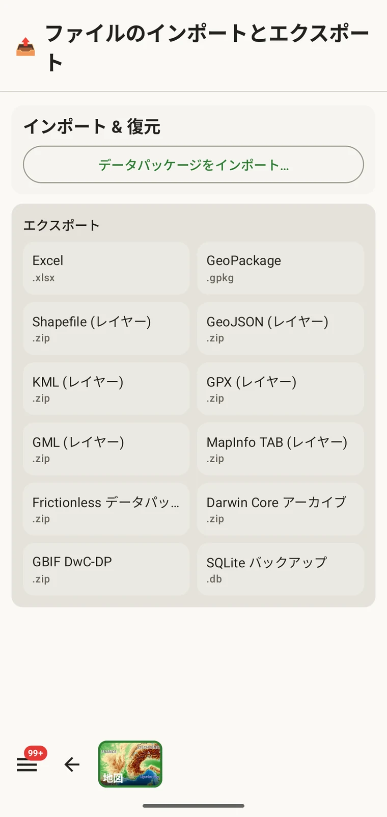
12 の形式
12 の形式はすべてデバイス上で書き出されます。サーバーは関与せず、接続も必要ありません。
| 形式 | ファイル | 用途 |
|---|---|---|
| Excel | .xlsx | Excel や類似のツールで作業する同僚向けの表計算ブック |
| GeoPackage | .gpkg | 単一ファイルの OGC 空間データコンテナ。QGIS や ArcGIS には最も適した既定の選択肢です |
| Shapefile(レイヤー) | .zip | エンティティ型ごとに 1 レイヤーの ESRI Shapefile 一式を、zip アーカイブにまとめたもの |
| GeoJSON(レイヤー) | .zip | RFC 7946 の GeoJSON。エンティティ型ごとに 1 ファイルを zip アーカイブにまとめたもの |
| KML(レイヤー) | .zip | Google Earth や KML に対応するツール向けの Keyhole Markup Language。zip アーカイブにまとめたもの |
| GPX(レイヤー) | .zip | GPS 機器やトラック用ツール向けの GPS Exchange Format。zip アーカイブにまとめたもの |
| GML(レイヤー) | .zip | OGC の XML 形式である Geography Markup Language。zip アーカイブにまとめたもの |
| MapInfo TAB (layers) | .zip | MapInfo interchange files (MIF/MID) for MapInfo Pro, in a zip archive |
| Frictionless データパッケージ | .zip | datapackage.json 記述子を備えた自己記述型の表形式パッケージ。リポジトリへの登録やデータ論文に適します |
| Darwin Core アーカイブ | .zip | GBIF および大半の生物多様性リポジトリにおける標準の取り込み形式 |
| GBIF DwC-DP | .zip | より新しい GBIF のデータパッケージモデル。これを必要とする提出先向けです |
| SQLite バックアップ | .db | A complete copy of the app's on-device database, all projects included |
生物多様性の標準規格
Darwin Core Archive は、GBIF をはじめとする多くの生物多様性リポジトリが取り込む形式です。出現レコードは Darwin Core の用語にマッピングされ、meta.xml 記述子とともにパッケージ化されるため、リポジトリは追加の変換なしにアーカイブをインポートできます。GBIF DwC-DP は、より新しい GBIF のデータパッケージモデルで、相互にリンクした CSV テーブル(イベント、出現、資料、メディア)の集合です。これを要求する提出先や、アーカイブ形式より表形式の表現を好む提出先に向いています。Frictionless Data Package は、CSV テーブルと datapackage.json 記述子からなる自己記述型の zip を生成します。データ論文に添えるリポジトリ登録や、テーブルとともに Frictionless のデータパッケージを求めるワークフローに適した選択肢です。
空間データの形式
GeoPackage is a single .gpkg file that holds all entity types in separate layers inside an SQLite container — the OGC standard for portable spatial data and the best default choice for QGIS or ArcGIS. The remaining spatial formats — Shapefile, GeoJSON, KML, GPX, GML and MapInfo TAB — are marked "(layers)" because they cannot express multiple feature types in a single file. Each one is exported as a .zip archive containing one file (or file set, for Shapefile) per entity type: observations, localities, visits (with their routes), diary entries and specimens. Unzip the archive before loading it into your GIS.
一般
Excel (.xlsx) produces a workbook, one worksheet per entity, for a colleague who works in a spreadsheet. SQLite backup (.db) is a raw copy of the app's whole database — every project — for archiving or for opening in any SQLite tool. It cannot be imported back into the app; to move data between devices use the Frictionless Data Package with Import data package…, or Backup & Restore under Menu → Admin → Account.
エクスポートの実行
- ホーム画面でエクスポートしたいプロジェクトを選択します。
- Open Menu → Admin → File Import & Export.
- エクスポートのグリッドから目的の形式をタップします。
- ファイルが書き出されるまで待ちます。写真を含む大きなプロジェクトほど時間がかかり、画面には進捗が表示されます。
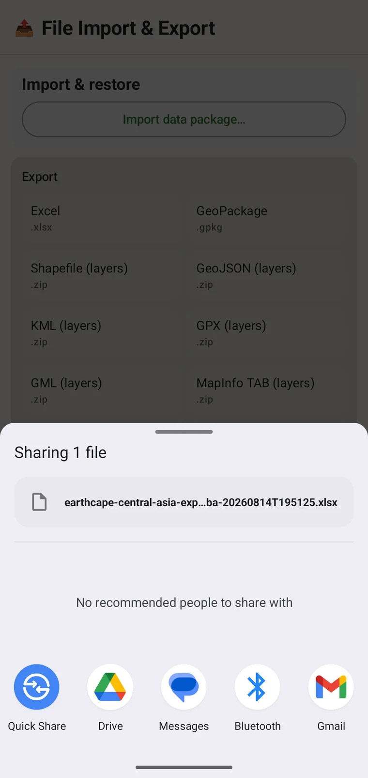
- When writing is complete, the Android share sheet appears so you can choose where the file goes. A Save to Downloads action is also offered if you prefer to keep the file on the device.
ファイル名はプロジェクト名とタイムスタンプから生成されます。たとえば earthcape-central-asia-exp…ba-20260814T195125.xlsx のようになります。エクスポートごとに一意の名前が付くため、同じプロジェクトを繰り返しエクスポートしても互いに上書きされません。
ファイルの送り先
Once the file is written, the Android share sheet opens with the usual destinations: Quick Share, Drive, Messages, Bluetooth, Gmail, and any other app registered on your device that accepts files. You can share the export immediately, or save it locally and upload later. If you have configured a cloud destination (see below), you can export the project there directly from its Integrations page instead of using the share sheet.
クラウドの送信先
Three cloud destinations are available under Menu → Admin → Integrations: Google Drive, Dropbox and Zenodo. Open a provider's page to sign in and to export the current project there; the export screen itself writes local files only.
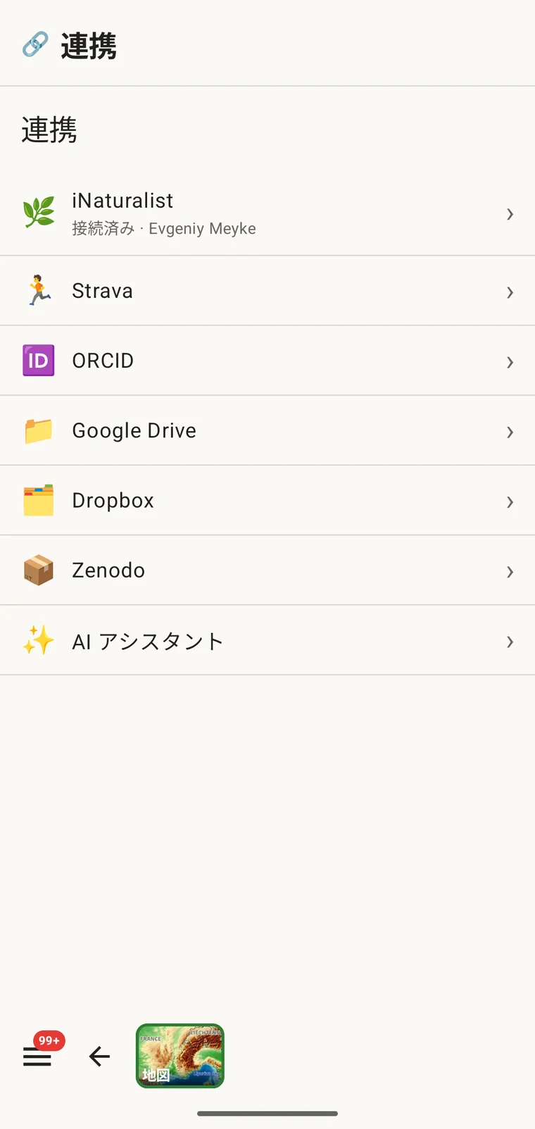
Google Drive と Dropbox は、作業ファイルやチームでの共同作業に適しています。共有フォルダーにエクスポートを置けば、同僚がそれを取得します。Zenodo は CERN が運営する研究リポジトリで、登録ごとに DOI を発行するため、出版物に添える引用可能なアーカイブ済みデータの公開に適しています。Drive を使った共同作業の手順全体については Google Drive での共同作業 をご覧ください。
GBIF への公開は行いません。 EarthCape はレコードを GBIF に直接送信しません。GBIF に提供するには、Darwin Core Archive をエクスポートし、所属機関または GBIF が承認したデータ公開者を通じて提出してください。
プロジェクトパッケージ:インポートと復元
画面上部の データパッケージをインポート… の項目は、別の種類のファイル、すなわちプロジェクトパッケージを扱います。プロジェクトパッケージは、プロトコル、フォームのレイアウト、カスタムフィールド、設定といったプロジェクトの構成を保持するため、設定済みのプロジェクトを同僚に渡したり、設定を失わずにプロジェクトを新しいデバイスへ移したりできます。
プロジェクトパッケージはデータのエクスポートとは別物です。GIS やリポジトリへの取り込みを目的としたものではなく、設定済みの作業環境をあるインストールから別のインストールへ移すためのものです。カスタムフィールドの定義、プロトコルの選択、フォームのレイアウトは、いずれもパッケージとともに移動します。カスタムフィールドの仕組みについては フォームとカスタムフィールド、プロトコルの設定については 調査プロトコル をご覧ください。
形式の選択
適切な形式は、データをどう扱うかによって決まります。
| 送り先または用途 | 選ぶ形式 |
|---|---|
| GBIF または生物多様性リポジトリへの提出 | Darwin Core Archive、リポジトリが求める場合は GBIF DwC-DP |
| QGIS または ArcGIS で開く | GeoPackage — 単一ファイルで、すべてのレイヤーを含みます |
| 表計算を使う同僚に送る | Excel |
| データ論文の登録、またはスキーマ要件のあるリポジトリ | Frictionless データパッケージ |
| 完全なバックアップ、または別のデバイスへの移行 | SQLite バックアップ |
| GPS 機器または他のトラックアプリケーション | GPX |
| Google Earth での表示 | KML |
| DOI を伴う引用可能なアーカイブ登録 | Zenodo に送る任意の形式 |
オフラインでの作業
12 の形式はすべて、完全にデバイス上で書き出されます。エクスポートに接続は必要ありません。ファイルはローカルのデータベースから組み立てられ、ローカルストレージに書き込まれます。アップロードの完了に電波が必要なのは、Drive、Dropbox、Zenodo というクラウドの送信先だけです。通信のない野外にいる場合は、まずローカルファイルにエクスポートし、接続できるようになってからクラウドの送信先へ送ってください。