
連携
GBIF 近隣の種
The app queries the published GBIF occurrence record around your current position and returns the taxa that have been recorded there, arranged in a taxonomic tree you can expand level by level and download from. It shows which groups are represented, how many distinct species (or higher taxa, at the detail level you choose) each group holds in the published record, and which names belong to those groups, before you start your own recording.
開き方
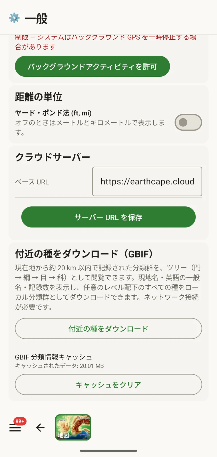
The entry point is the Download nearby species (GBIF) card under Menu → Admin → General; it is also offered during first-run setup. Scroll to the card and tap Download nearby species. The query runs against the live GBIF API, so you need a connection. Run it before you leave for the field, not once you have lost signal.
問い合わせで返される内容
The query looks at GBIF occurrence records within 20 km of your current position and groups them by phylum, giving for each phylum the number of distinct taxa at the chosen detail level (species by default). The sheet shows the top-level summary once Get data has run.
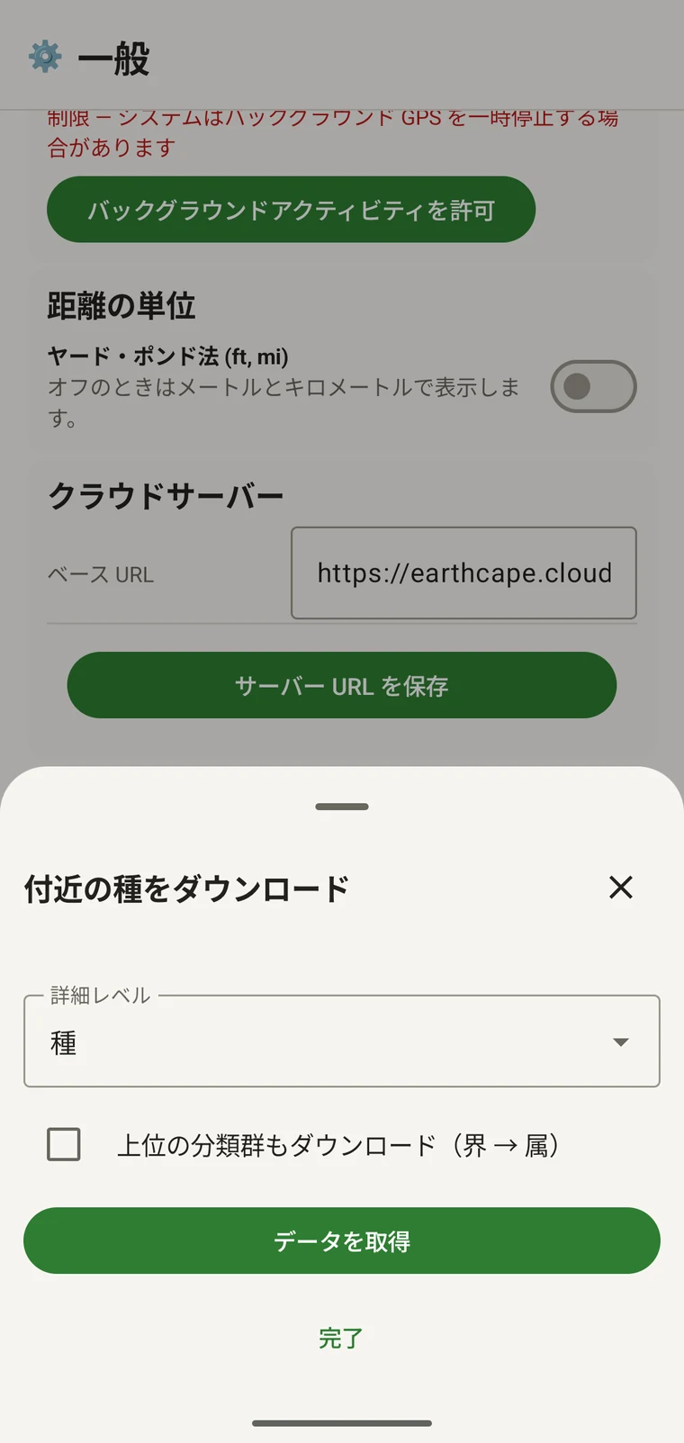
On opening, the sheet shows two controls and two buttons:
- Detail level (Phylum, Class, Order, Family or Species; Species is the default) — sets how far down the taxonomy the download goes when you tick a group.
- Also download parent taxa (kingdom → genus) checkbox — off by default; covered in its own section below.
- Get data — takes a GPS fix and loads the taxonomic tree for the area. Nothing is downloaded yet.
- 完了 — シートを閉じます。
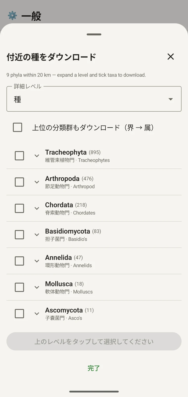
Once the tree has loaded the header reads, for example, "9 phyla within 20 km — expand a level and tick taxa to download.", a Select all row appears above the tree, and a Download N selected button replaces Get data.
以下の例は、ある山岳地帯での調査によるものです。実際の調査地では、それぞれ異なる数値が返されます。
| 門 | Species within 20 km |
|---|---|
| Tracheophyta | 895 |
| Arthropoda | 476 |
| Chordata | 218 |
| Basidiomycota | 83 |
| Annelida | 47 |
| Mollusca | 18 |
| Ascomycota | 11 |
階層をたどる
Tap a phylum to expand it to its constituent classes, and tap a class to expand to orders. At each level the number in brackets is the count of distinct taxa at the chosen detail level recorded under that group within the search radius. A count shown as 1,000+ has hit the query cap.
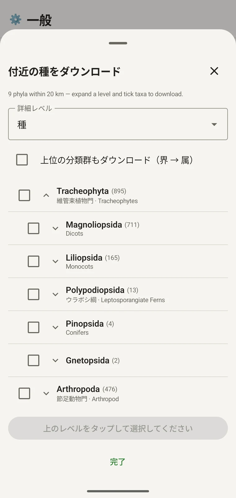
同じ例を続けると、Tracheophyta は Magnoliopsida 711、Liliopsida 165、Polypodiopsida 13、Pinopsida 4、Gnetopsida 2 に展開されます。Magnoliopsida を展開すると Asterales 115、Lamiales 100、Fabales 93、Rosales 56、Caryophyllales 49 となり、それぞれに一般名が表示されます。
The counts are numbers of distinct taxa in the published record, not record totals and not abundance estimates. A high count means many taxa in that group have been recorded and published for this area; a low count means the group is either genuinely species-poor here or simply under-surveyed and under-published. The distinction matters when you use the figures to plan work — see the section on survey planning below.
詳細レベルと上位分類群
The Detail level control sets the rank down to which taxa are downloaded when you tick a group. At Species, the download includes all species in GBIF's record for that group within the radius. If you are working at a coarser resolution — mapping genera only, for example — you can set the detail level to Family, Order, Class or Phylum to reduce the volume of names brought onto the device.
The Also download parent taxa (kingdom → genus) checkbox controls whether the higher ranks are fetched alongside the species. It is off by default; tick it in almost every case. Without it, the species names arrive on the device as orphans: the taxonomy held locally has no genus, family or order to attach them to, so they cannot be browsed by higher taxon and any rollup by group in your own data will not resolve correctly. Leave it off only if storage is genuinely tight and you intend to work entirely at species level with no hierarchical browsing.
分類群をデバイスにダウンロードする
Nothing is pre-loaded onto the device for any particular site. The GBIF query populates the local taxonomy with GBIF Backbone names known to occur nearby, so when you record an observation you are picking from taxa that have actually been found at the site, rather than searching the full global list — and those names stay on the device once they are downloaded.
- 詳細レベルを、記録の必要に合ったランクに設定します。既定は種です。
- Tap Get data to load the tree for your position.
- 門をタップして展開し、さらに目的の綱または目まで展開します。
- 記録する予定のグループごとに、横のチェックボックスにチェックを入れます。どのランクでもチェックできます。綱にチェックを入れると、設定した詳細レベルまで、その構成分類群がすべてダウンロードされます。
- Tick Also download parent taxa unless storage is genuinely tight.
- Tap Download N selected. The app fetches the ticked taxa from GBIF and writes them to the local database in the background; a notification shows progress and you can close the sheet meanwhile.
- 完了をタップしてシートを閉じます。
ダウンロードした名称は、観察記録の入力で観察を入力する際にオフラインで検索できます。全世界の分類体系を相手に記憶で入力するのではなく、その地域で確認されている名称から選ぶことになります。
調査計画への活用
フィールドシーズンの前に、対象の調査地について問い合わせを実行し、何もダウンロードする前に門レベルの件数を確認してください。件数の分布から、その地域の公開レコードで十分に記録されているグループと、ほとんど登録がないグループが分かります。
A phylum with a handful of taxa is either genuinely absent from the site or under-surveyed and under-published there. Both cases are useful to know before a trip: genuine absence tells you where not to spend effort, and a thin published record for a group you expect to be present identifies a gap you can target.
その回の調査で実際に記録するグループについてだけ分類群をダウンロードしてください。単一の門を対象に作業しているのであれば、ツリー全体をデバイスに読み込む利点はありません。ダウンロードには時間と、確保できないかもしれない通信帯域がかかります。
制限事項
この問い合わせには GBIF API への接続が必要です。オフラインでは実行できません。そのため、接続のある場所を離れる前に実行することが想定された手順になっています。
The search radius is 20 km around your current position. This is fixed by the query; there is no radius control in the app.
件数は GBIF に公開された内容を反映しています。カバー範囲は地域間でも分類群間でも偏りがあります。西ヨーロッパの脊椎動物は一般によく整備されていますが、中央アジアの無脊椎動物や菌類はそうではありません。件数が少ないことは、そのグループとその場所の組み合わせについての公開レコードの状態を示すものであって、調査地そのものについての直接の情報ではありません。その点を踏まえて数値を解釈してください。
アプリから GBIF への公開機能はありません。この連携は読み取り専用で、既存のレコードを問い合わせ、分類群名をダウンロードするだけです。自分のデータを GBIF に提供するには、アプリから Darwin Core Archive または GBIF DwC-DP ファイルをエクスポートし、GBIF の標準的な手順で提出します。利用できるファイル形式はエクスポート形式を参照してください。