
التكاملات
الأنواع القريبة في GBIF
The app queries the published GBIF occurrence record around your current position and returns the taxa that have been recorded there, arranged in a taxonomic tree you can expand level by level and download from. It shows which groups are represented, how many distinct species (or higher taxa, at the detail level you choose) each group holds in the published record, and which names belong to those groups, before you start your own recording.
فتحه
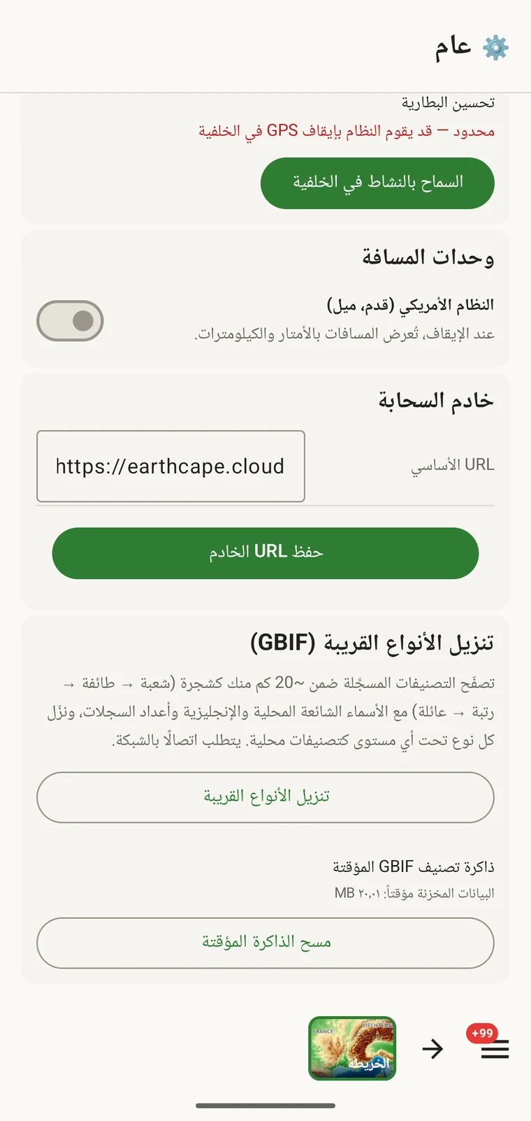
The entry point is the Download nearby species (GBIF) card under Menu → Admin → General; it is also offered during first-run setup. Scroll to the card and tap Download nearby species. The query runs against the live GBIF API, so you need a connection. Run it before you leave for the field, not once you have lost signal.
ما يعيده الاستعلام
The query looks at GBIF occurrence records within 20 km of your current position and groups them by phylum, giving for each phylum the number of distinct taxa at the chosen detail level (species by default). The sheet shows the top-level summary once Get data has run.
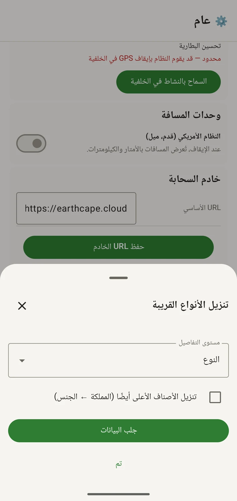
On opening, the sheet shows two controls and two buttons:
- Detail level (Phylum, Class, Order, Family or Species; Species is the default) — sets how far down the taxonomy the download goes when you tick a group.
- Also download parent taxa (kingdom → genus) checkbox — off by default; covered in its own section below.
- Get data — takes a GPS fix and loads the taxonomic tree for the area. Nothing is downloaded yet.
- تم — يغلق الورقة.
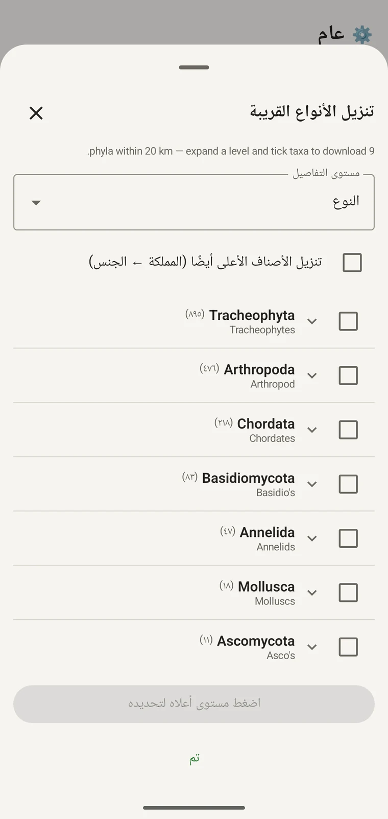
Once the tree has loaded the header reads, for example, "9 phyla within 20 km — expand a level and tick taxa to download.", a Select all row appears above the tree, and a Download N selected button replaces Get data.
المثال أدناه من مسح واحد في منطقة جبلية. وسيعيد موقعك أنت أرقامه الخاصة.
| الشُّعبة | Species within 20 km |
|---|---|
| Tracheophyta | 895 |
| Arthropoda | 476 |
| Chordata | 218 |
| Basidiomycota | 83 |
| Annelida | 47 |
| Mollusca | 18 |
| Ascomycota | 11 |
التعمّق في الشجرة
Tap a phylum to expand it to its constituent classes, and tap a class to expand to orders. At each level the number in brackets is the count of distinct taxa at the chosen detail level recorded under that group within the search radius. A count shown as 1,000+ has hit the query cap.
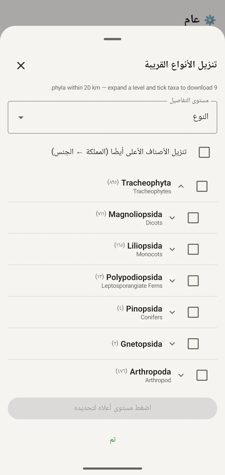
متابعةً للمثال نفسه: تتوسع Tracheophyta إلى Magnoliopsida بـ711، وLiliopsida بـ165، وPolypodiopsida بـ13، وPinopsida بـ4، وGnetopsida بـ2. وتوسيع Magnoliopsida يعطي Asterales بـ115، وLamiales بـ100، وFabales بـ93، وRosales بـ56، وCaryophyllales بـ49، ويُعرض كلٌّ منها باسمه الشائع.
The counts are numbers of distinct taxa in the published record, not record totals and not abundance estimates. A high count means many taxa in that group have been recorded and published for this area; a low count means the group is either genuinely species-poor here or simply under-surveyed and under-published. The distinction matters when you use the figures to plan work — see the section on survey planning below.
مستوى التفاصيل والتصنيفات الأصلية
The Detail level control sets the rank down to which taxa are downloaded when you tick a group. At Species, the download includes all species in GBIF's record for that group within the radius. If you are working at a coarser resolution — mapping genera only, for example — you can set the detail level to Family, Order, Class or Phylum to reduce the volume of names brought onto the device.
The Also download parent taxa (kingdom → genus) checkbox controls whether the higher ranks are fetched alongside the species. It is off by default; tick it in almost every case. Without it, the species names arrive on the device as orphans: the taxonomy held locally has no genus, family or order to attach them to, so they cannot be browsed by higher taxon and any rollup by group in your own data will not resolve correctly. Leave it off only if storage is genuinely tight and you intend to work entirely at species level with no hierarchical browsing.
تنزيل التصنيفات إلى الجهاز
Nothing is pre-loaded onto the device for any particular site. The GBIF query populates the local taxonomy with GBIF Backbone names known to occur nearby, so when you record an observation you are picking from taxa that have actually been found at the site, rather than searching the full global list — and those names stay on the device once they are downloaded.
- اضبط مستوى التفاصيل على الرتبة التي تناسب احتياجات تسجيلك. والأنواع هي الافتراضي.
- Tap Get data to load the tree for your position.
- انقر شُعبة لتوسيعها، ثم وسّع أكثر إلى الطائفة أو الرتبة التي تريدها.
- أشّر على مربع الاختيار بجانب كل مجموعة ستسجّلها. ويمكنك التأشير عند أي رتبة — فالتأشير على طائفة ينزّل كل وحداتها التصنيفية المكوِّنة نزولاً إلى مستوى التفاصيل الذي ضبطته.
- Tick Also download parent taxa unless storage is genuinely tight.
- Tap Download N selected. The app fetches the ticked taxa from GBIF and writes them to the local database in the background; a notification shows progress and you can close the sheet meanwhile.
- انقر تم لإغلاق الورقة.
وتصبح الأسماء المنزَّلة عندئذ قابلة للبحث بلا إنترنت حين تُدخل المشاهدات في تسجيل المشاهدات. فأنت تنتقي من أسماء معروف تواجدها محلياً بدل الكتابة من الذاكرة مقابل التصنيف العالمي الكامل.
استخدامه لتخطيط مسح
قبل موسم ميداني، شغّل الاستعلام على الموقع الذي تقصده واقرأ الأعداد على مستوى الشُّعبة قبل تنزيل أي شيء. فتوزّع الأعداد يخبرك أي المجموعات ممثَّلة تمثيلاً جيداً في السجل المنشور لتلك المنطقة وأيها بالكاد حاضرة.
A phylum with a handful of taxa is either genuinely absent from the site or under-surveyed and under-published there. Both cases are useful to know before a trip: genuine absence tells you where not to spend effort, and a thin published record for a group you expect to be present identifies a gap you can target.
نزّل الوحدات التصنيفية للمجموعات التي ستسجّلها فعلياً في رحلة بعينها فقط. فلا فائدة من تحميل الشجرة كاملة على الجهاز إن كنت تعمل على شُعبة واحدة؛ إذ يستهلك التنزيل وقتاً وعرض نطاق اتصال قد لا يتوفر لك.
الحدود
يتطلب الاستعلام اتصالاً حياً بواجهة GBIF البرمجية. ولا يمكن تشغيله بلا إنترنت، ولهذا يقضي سير العمل المقصود بتشغيله قبل مغادرة موضع متصل.
The search radius is 20 km around your current position. This is fixed by the query; there is no radius control in the app.
تعكس الأعداد ما نُشر إلى GBIF. والتغطية متفاوتة بين المناطق وبين المجموعات التصنيفية: فالفقاريات في غرب أوروبا ممثَّلة تمثيلاً جيداً عادةً؛ أما اللافقاريات والفطريات في آسيا الوسطى فلا. والعدد المنخفض قول عن السجل المنشور لذلك الاقتران بين المجموعة والموقع، لا قول مباشر عن الموقع نفسه. ففسّر الأرقام واضعاً ذلك في الحسبان.
ولا نشر من التطبيق إلى GBIF. فالتكامل للقراءة فقط: تستعلم عن سجلات قائمة وتنزّل أسماء تصنيفية. وللمساهمة ببياناتك في GBIF تصدّر من التطبيق ملف Darwin Core Archive أو GBIF DwC-DP وتقدّمه عبر المسار القياسي لـGBIF — انظر صيغ التصدير للاطلاع على صيغ الملفات المتاحة.