
数据
导出格式
EarthCape writes to twelve formats — biodiversity archives, spatial files, spreadsheets and a full database backup — directly on the device, with no account and no connection required. Cloud destinations need a connection. They are the formats a repository, a GIS or a colleague will accept without conversion.
导出界面
Select a project first. The export screen is at Menu → Admin → File Import & Export. The screen is divided into two sections. At the top is Import & restore, with a single entry, Import data package…, which reads a Frictionless Data Package — one you exported earlier, or one a colleague sends you. Below it is the Export grid, which lists all twelve formats by name and file extension. Tap a format to begin.
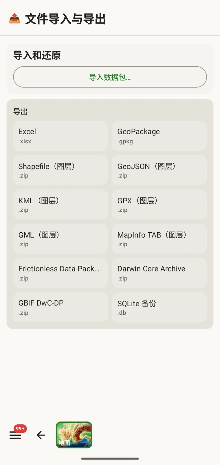
十二种格式
全部十二种格式都在设备上写出。不涉及服务器,也不需要网络连接。
| 格式 | 文件 | 用途 |
|---|---|---|
| Excel | .xlsx | 供使用 Excel 或类似工具的同事使用的电子表格工作簿 |
| GeoPackage | .gpkg | 单文件 OGC 空间容器,QGIS 或 ArcGIS 的最佳默认选择 |
| Shapefile(图层) | .zip | ESRI Shapefile 文件集,每种实体类型一个图层,打包为 zip 压缩包 |
| GeoJSON(图层) | .zip | 符合 RFC 7946 的 GeoJSON,每种实体类型一个文件,打包为 zip 压缩包 |
| KML(图层) | .zip | 面向 Google Earth 及支持 KML 的工具的 Keyhole Markup Language,打包为 zip 压缩包 |
| GPX(图层) | .zip | 面向 GPS 设备和轨迹工具的 GPS Exchange Format,打包为 zip 压缩包 |
| GML(图层) | .zip | Geography Markup Language,一种 OGC XML 格式,打包为 zip 压缩包 |
| MapInfo TAB (layers) | .zip | MapInfo interchange files (MIF/MID) for MapInfo Pro, in a zip archive |
| Frictionless Data Package | .zip | 带有 datapackage.json 描述文件的自描述表格数据包,适合仓储存缴和数据论文 |
| Darwin Core Archive | .zip | GBIF 和大多数生物多样性数据仓储的标准导入格式 |
| GBIF DwC-DP | .zip | 较新的 GBIF 数据包模型,用于要求使用它的提交 |
| SQLite 备份 | .db | A complete copy of the app's on-device database, all projects included |
生物多样性标准
Darwin Core Archive 是 GBIF 和大多数生物多样性数据仓储所接收的格式。出现记录会映射到 Darwin Core 术语,并与一份 meta.xml 描述文件一同打包,因此数据仓储无需再做转换即可导入该档案。GBIF DwC-DP 是较新的 GBIF 数据包模型——一组相互关联的 CSV 表(事件、出现记录、材料和媒体),面向要求使用它、或相比档案格式更倾向表格表示的提交。Frictionless Data Package 生成一个自描述的 zip,内含 CSV 表以及一份 datapackage.json 描述文件。若要在数据仓储中存放与数据论文配套的数据,或用于任何期望在表格之外还附带 Frictionless 数据包的工作流程,它都是不错的选择。
空间格式
GeoPackage is a single .gpkg file that holds all entity types in separate layers inside an SQLite container — the OGC standard for portable spatial data and the best default choice for QGIS or ArcGIS. The remaining spatial formats — Shapefile, GeoJSON, KML, GPX, GML and MapInfo TAB — are marked "(layers)" because they cannot express multiple feature types in a single file. Each one is exported as a .zip archive containing one file (or file set, for Shapefile) per entity type: observations, localities, visits (with their routes), diary entries and specimens. Unzip the archive before loading it into your GIS.
常规
Excel (.xlsx) produces a workbook, one worksheet per entity, for a colleague who works in a spreadsheet. SQLite backup (.db) is a raw copy of the app's whole database — every project — for archiving or for opening in any SQLite tool. It cannot be imported back into the app; to move data between devices use the Frictionless Data Package with Import data package…, or Backup & Restore under Menu → Admin → Account.
导出
- 在主屏幕上选择您要导出的项目。
- Open Menu → Admin → File Import & Export.
- 在导出网格中点按您需要的格式。
- 等待文件写入完成。含照片的较大项目耗时更长;界面会显示进度。
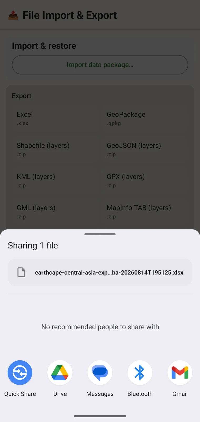
- When writing is complete, the Android share sheet appears so you can choose where the file goes. A Save to Downloads action is also offered if you prefer to keep the file on the device.
文件名由项目名称和时间戳生成,例如 earthcape-central-asia-exp…ba-20260814T195125.xlsx。每次导出都会得到唯一的名称,因此同一项目的重复导出不会相互覆盖。
文件的去向
Once the file is written, the Android share sheet opens with the usual destinations: Quick Share, Drive, Messages, Bluetooth, Gmail, and any other app registered on your device that accepts files. You can share the export immediately, or save it locally and upload later. If you have configured a cloud destination (see below), you can export the project there directly from its Integrations page instead of using the share sheet.
云端目标位置
Three cloud destinations are available under Menu → Admin → Integrations: Google Drive, Dropbox and Zenodo. Open a provider's page to sign in and to export the current project there; the export screen itself writes local files only.
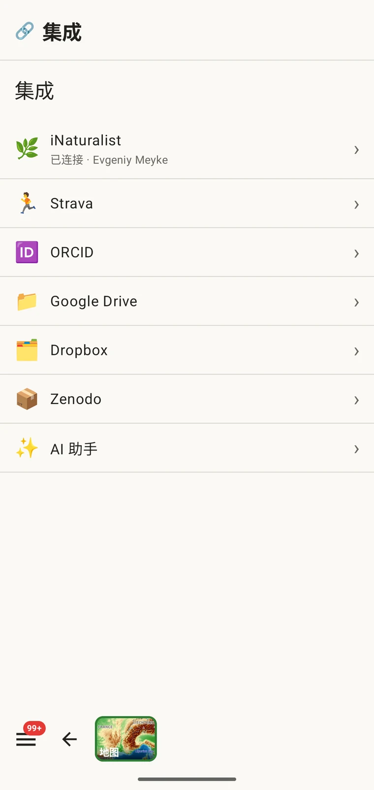
Google Drive 和 Dropbox 适合工作文件和团队协作——您把导出文件放到共享文件夹,同事再取走。Zenodo 是由 CERN 运行的科研数据仓储,会为每次存放签发一个 DOI,因此适合与论文一同发布的可引用存档数据集。使用 Drive 的完整协作流程参见Google Drive 协作。
不支持向 GBIF 发布。EarthCape 不会直接向 GBIF 提交记录。要向 GBIF 贡献数据,请导出 Darwin Core Archive,并通过您所在的机构或 GBIF 认可的数据发布方提交。
项目包:导入与还原
界面顶部的导入数据包…条目处理的是另一类文件:项目包。项目包携带一个项目的配置——它的协议、表单布局、自定义字段和设置——因此您可以把配置好的项目交给同事,或者把项目迁移到新设备而不丢失配置。
项目包不同于数据导出。它们不是用来导入 GIS 或数据仓储的;它们用于把配置好的工作环境从一个安装迁移到另一个安装。自定义字段定义、协议选择和表单布局都会随包一起迁移。自定义字段的工作方式参见表单与自定义字段,协议配置参见调查协议。
选择格式
选择哪种格式取决于您要用这些数据做什么。
| 目标或用途 | 应选择的格式 |
|---|---|
| 提交给 GBIF 或生物多样性数据仓储 | Darwin Core Archive;如果数据仓储有要求,则用 GBIF DwC-DP |
| 在 QGIS 或 ArcGIS 中打开 | GeoPackage——单个文件,包含所有图层 |
| 发送给使用电子表格的同事 | Excel |
| 数据论文存放,或对模式有要求的数据仓储 | Frictionless Data Package |
| 完整备份或迁移到另一台设备 | SQLite 备份 |
| GPS 设备或其他轨迹应用 | GPX |
| 在 Google Earth 中查看 | KML |
| 带 DOI 的可引用存档存放 | 发送到 Zenodo 的任意格式 |
离线工作
全部十二种格式完全在设备上写出。导出不需要网络连接:文件由本地数据库组装并写入本地存储。只有云端目标位置——Drive、Dropbox、Zenodo——需要信号才能完成上传。如果您身处没有连接的野外,可以先导出为本地文件,等有了连接之后再发送到云端目标位置。