
Integrações
Espécies próximas no GBIF
The app queries the published GBIF occurrence record around your current position and returns the taxa that have been recorded there, arranged in a taxonomic tree you can expand level by level and download from. It shows which groups are represented, how many distinct species (or higher taxa, at the detail level you choose) each group holds in the published record, and which names belong to those groups, before you start your own recording.
Como abrir
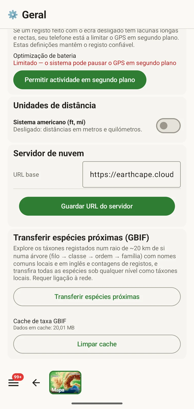
The entry point is the Download nearby species (GBIF) card under Menu → Admin → General; it is also offered during first-run setup. Scroll to the card and tap Download nearby species. The query runs against the live GBIF API, so you need a connection. Run it before you leave for the field, not once you have lost signal.
O que a consulta devolve
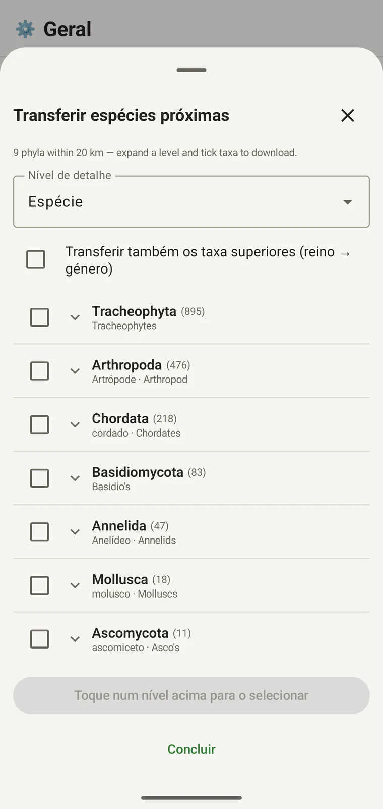
The query looks at GBIF occurrence records within 20 km of your current position and groups them by phylum, giving for each phylum the number of distinct taxa at the chosen detail level (species by default). The sheet shows the top-level summary once Get data has run.
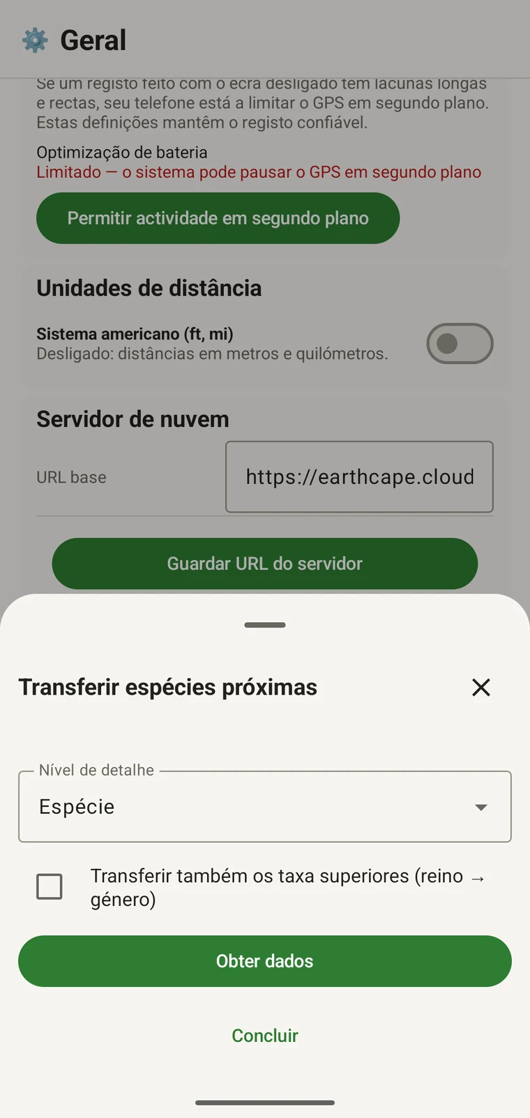
On opening, the sheet shows two controls and two buttons:
- Detail level (Phylum, Class, Order, Family or Species; Species is the default) — sets how far down the taxonomy the download goes when you tick a group.
- Also download parent taxa (kingdom → genus) checkbox — off by default; covered in its own section below.
- Get data — takes a GPS fix and loads the taxonomic tree for the area. Nothing is downloaded yet.
- Concluído — fecha o painel.
Once the tree has loaded the header reads, for example, "9 phyla within 20 km — expand a level and tick taxa to download.", a Select all row appears above the tree, and a Download N selected button replaces Get data.
O exemplo abaixo provém de um levantamento de montanha. O seu próprio local devolverá os seus próprios números.
| Filo | Species within 20 km |
|---|---|
| Tracheophyta | 895 |
| Arthropoda | 476 |
| Chordata | 218 |
| Basidiomycota | 83 |
| Annelida | 47 |
| Mollusca | 18 |
| Ascomycota | 11 |
Explorar em profundidade
Tap a phylum to expand it to its constituent classes, and tap a class to expand to orders. At each level the number in brackets is the count of distinct taxa at the chosen detail level recorded under that group within the search radius. A count shown as 1,000+ has hit the query cap.
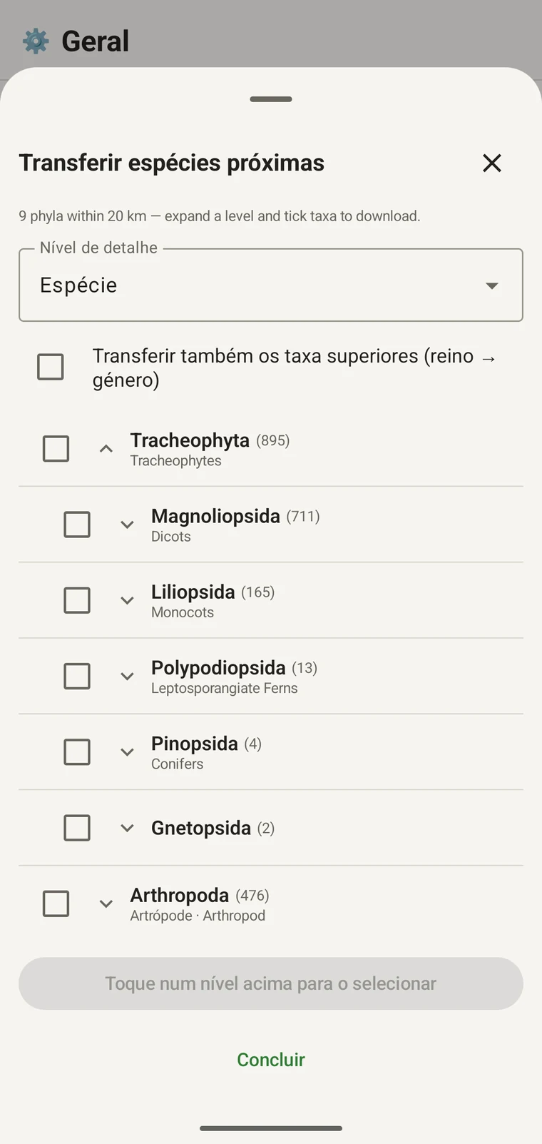
Continuando o mesmo exemplo: Tracheophyta expande-se em Magnoliopsida 711, Liliopsida 165, Polypodiopsida 13, Pinopsida 4, Gnetopsida 2. Ao expandir Magnoliopsida obtêm-se Asterales 115, Lamiales 100, Fabales 93, Rosales 56, Caryophyllales 49, cada uma apresentada com o seu nome vernáculo.
The counts are numbers of distinct taxa in the published record, not record totals and not abundance estimates. A high count means many taxa in that group have been recorded and published for this area; a low count means the group is either genuinely species-poor here or simply under-surveyed and under-published. The distinction matters when you use the figures to plan work — see the section on survey planning below.
Nível de detalhe e táxones ascendentes
The Detail level control sets the rank down to which taxa are downloaded when you tick a group. At Species, the download includes all species in GBIF's record for that group within the radius. If you are working at a coarser resolution — mapping genera only, for example — you can set the detail level to Family, Order, Class or Phylum to reduce the volume of names brought onto the device.
The Also download parent taxa (kingdom → genus) checkbox controls whether the higher ranks are fetched alongside the species. It is off by default; tick it in almost every case. Without it, the species names arrive on the device as orphans: the taxonomy held locally has no genus, family or order to attach them to, so they cannot be browsed by higher taxon and any rollup by group in your own data will not resolve correctly. Leave it off only if storage is genuinely tight and you intend to work entirely at species level with no hierarchical browsing.
Transferir táxones para o dispositivo
Nothing is pre-loaded onto the device for any particular site. The GBIF query populates the local taxonomy with GBIF Backbone names known to occur nearby, so when you record an observation you are picking from taxa that have actually been found at the site, rather than searching the full global list — and those names stay on the device once they are downloaded.
- Defina o Nível de detalhe para a categoria taxonómica que corresponde às suas necessidades de registo. Espécies é a predefinição.
- Tap Get data to load the tree for your position.
- Toque num filo para o expandir e continue a expandir até à classe ou à ordem pretendida.
- Assinale a caixa de verificação junto a cada grupo que vai registar. Pode assinalar em qualquer categoria taxonómica — assinalar uma classe transfere todos os táxones que a compõem até ao nível de detalhe que definiu.
- Tick Also download parent taxa unless storage is genuinely tight.
- Tap Download N selected. The app fetches the ticked taxa from GBIF and writes them to the local database in the background; a notification shows progress and you can close the sheet meanwhile.
- Toque em Concluído para fechar o painel.
Os nomes transferidos ficam depois pesquisáveis offline quando introduz observações em Registar observações. Está a escolher entre nomes que se sabe ocorrerem localmente, em vez de escrever de memória a partir da taxonomia global completa.
Utilizar a consulta para planear um levantamento
Antes de uma época de campo, execute a consulta sobre o local pretendido e leia as contagens ao nível do filo antes de transferir seja o que for. A distribuição das contagens indica que grupos estão bem representados no registo publicado dessa área e quais estão quase ausentes.
A phylum with a handful of taxa is either genuinely absent from the site or under-surveyed and under-published there. Both cases are useful to know before a trip: genuine absence tells you where not to spend effort, and a thin published record for a group you expect to be present identifies a gap you can target.
Transfira táxones apenas para os grupos que vai registar ativamente numa determinada deslocação. Não há vantagem em carregar a árvore completa no dispositivo se estiver a trabalhar num único filo; a transferência consome tempo e largura de banda que pode não ter.
Limites
A consulta requer uma ligação ativa à API do GBIF. Não pode ser executada offline, razão pela qual o fluxo de trabalho previsto é executá-la antes de sair de um local com ligação.
The search radius is 20 km around your current position. This is fixed by the query; there is no radius control in the app.
As contagens refletem o que foi publicado no GBIF. A cobertura é desigual entre regiões e entre grupos taxonómicos: os vertebrados na Europa ocidental estão habitualmente bem representados; os invertebrados e os fungos na Ásia central não estão. Uma contagem baixa é uma afirmação sobre o registo publicado para essa combinação de grupo e localização, não uma afirmação direta sobre o local. Interprete os números tendo isso em conta.
Não existe publicação da aplicação para o GBIF. A integração é apenas de leitura: consulta registos existentes e transfere nomes de táxones. Para contribuir com os seus próprios dados para o GBIF, exporte da aplicação um ficheiro Darwin Core Archive ou GBIF DwC-DP e submeta-o pela via normal do GBIF — consulte Formatos de exportação para os formatos de ficheiro disponíveis.