
Інтеграції
Види поблизу за GBIF
The app queries the published GBIF occurrence record around your current position and returns the taxa that have been recorded there, arranged in a taxonomic tree you can expand level by level and download from. It shows which groups are represented, how many distinct species (or higher taxa, at the detail level you choose) each group holds in the published record, and which names belong to those groups, before you start your own recording.
Як його відкрити
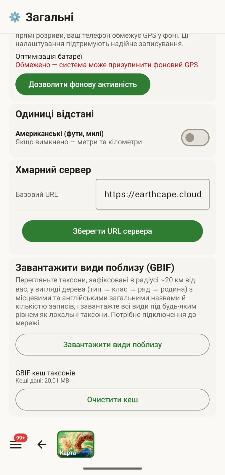
The entry point is the Download nearby species (GBIF) card under Menu → Admin → General; it is also offered during first-run setup. Scroll to the card and tap Download nearby species. The query runs against the live GBIF API, so you need a connection. Run it before you leave for the field, not once you have lost signal.
Що повертає запит
The query looks at GBIF occurrence records within 20 km of your current position and groups them by phylum, giving for each phylum the number of distinct taxa at the chosen detail level (species by default). The sheet shows the top-level summary once Get data has run.
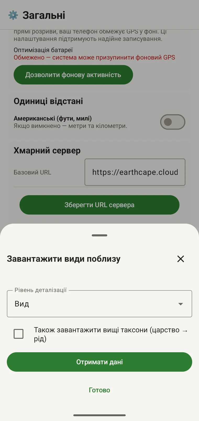
On opening, the sheet shows two controls and two buttons:
- Detail level (Phylum, Class, Order, Family or Species; Species is the default) — sets how far down the taxonomy the download goes when you tick a group.
- Also download parent taxa (kingdom → genus) checkbox — off by default; covered in its own section below.
- Get data — takes a GPS fix and loads the taxonomic tree for the area. Nothing is downloaded yet.
- Готово — закриває панель.
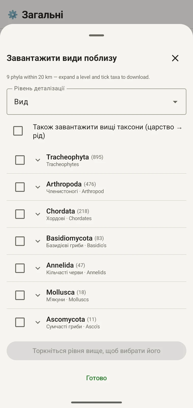
Once the tree has loaded the header reads, for example, "9 phyla within 20 km — expand a level and tick taxa to download.", a Select all row appears above the tree, and a Download N selected button replaces Get data.
Наведений нижче приклад узято з одного гірського обліку. Ваша власна ділянка дасть власні цифри.
| Тип | Species within 20 km |
|---|---|
| Tracheophyta | 895 |
| Arthropoda | 476 |
| Chordata | 218 |
| Basidiomycota | 83 |
| Annelida | 47 |
| Mollusca | 18 |
| Ascomycota | 11 |
Заглиблення в дерево
Tap a phylum to expand it to its constituent classes, and tap a class to expand to orders. At each level the number in brackets is the count of distinct taxa at the chosen detail level recorded under that group within the search radius. A count shown as 1,000+ has hit the query cap.
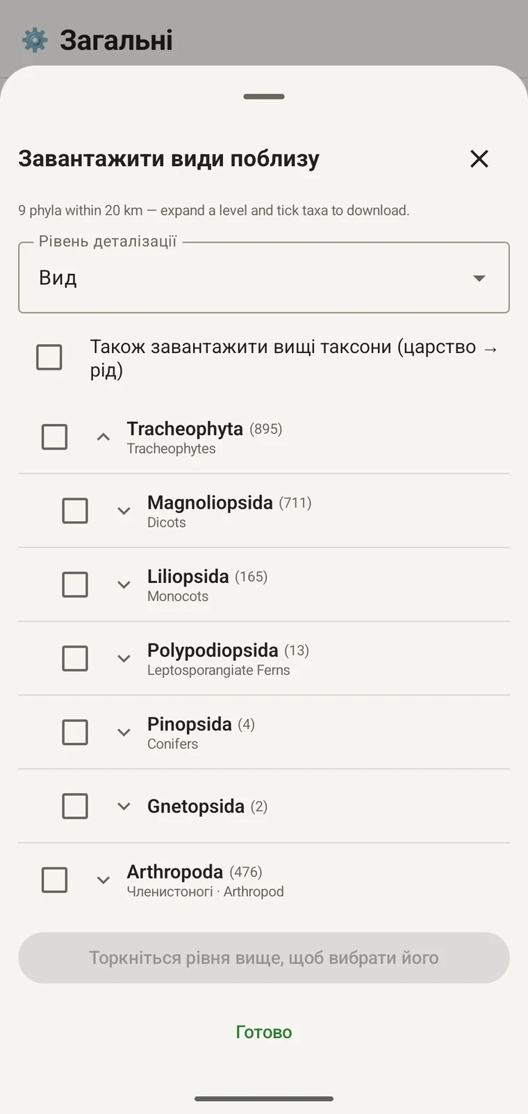
Продовжуючи той самий приклад: Tracheophyta розгортається до Magnoliopsida 711, Liliopsida 165, Polypodiopsida 13, Pinopsida 4, Gnetopsida 2. Розгортання Magnoliopsida дає Asterales 115, Lamiales 100, Fabales 93, Rosales 56, Caryophyllales 49, кожен із власною народною назвою.
The counts are numbers of distinct taxa in the published record, not record totals and not abundance estimates. A high count means many taxa in that group have been recorded and published for this area; a low count means the group is either genuinely species-poor here or simply under-surveyed and under-published. The distinction matters when you use the figures to plan work — see the section on survey planning below.
Рівень деталізації та батьківські таксони
The Detail level control sets the rank down to which taxa are downloaded when you tick a group. At Species, the download includes all species in GBIF's record for that group within the radius. If you are working at a coarser resolution — mapping genera only, for example — you can set the detail level to Family, Order, Class or Phylum to reduce the volume of names brought onto the device.
The Also download parent taxa (kingdom → genus) checkbox controls whether the higher ranks are fetched alongside the species. It is off by default; tick it in almost every case. Without it, the species names arrive on the device as orphans: the taxonomy held locally has no genus, family or order to attach them to, so they cannot be browsed by higher taxon and any rollup by group in your own data will not resolve correctly. Leave it off only if storage is genuinely tight and you intend to work entirely at species level with no hierarchical browsing.
Завантаження таксонів на пристрій
Nothing is pre-loaded onto the device for any particular site. The GBIF query populates the local taxonomy with GBIF Backbone names known to occur nearby, so when you record an observation you are picking from taxa that have actually been found at the site, rather than searching the full global list — and those names stay on the device once they are downloaded.
- Установіть Рівень деталізації на ранг, що відповідає вашим потребам запису. Типово це «Види».
- Tap Get data to load the tree for your position.
- Торкніться типу, щоб розгорнути його, а потім розгорніть далі до потрібного класу чи порядку.
- Позначте прапорець біля кожної групи, яку ви записуватимете. Позначати можна на будь-якому ранзі — позначення класу завантажує всі таксони, що до нього входять, аж до заданого вами рівня деталізації.
- Tick Also download parent taxa unless storage is genuinely tight.
- Tap Download N selected. The app fetches the ticked taxa from GBIF and writes them to the local database in the background; a notification shows progress and you can close the sheet meanwhile.
- Торкніться Готово, щоб закрити панель.
Завантажені назви після цього доступні для пошуку офлайн, коли ви вводите спостереження — див. Запис спостережень. Ви обираєте з назв, відомих для цієї місцевості, а не набираєте з пам'яті на тлі повної глобальної таксономії.
Використання для планування обліку
Перед польовим сезоном виконайте запит для наміченої ділянки й прочитайте кількості на рівні типів, перш ніж щось завантажувати. Розподіл кількостей показує, які групи добре представлені в опублікованих даних для цієї території, а які присутні ледь-ледь.
A phylum with a handful of taxa is either genuinely absent from the site or under-surveyed and under-published there. Both cases are useful to know before a trip: genuine absence tells you where not to spend effort, and a thin published record for a group you expect to be present identifies a gap you can target.
Завантажуйте таксони лише для тих груп, які ви активно записуватимете в конкретному виїзді. Немає сенсу завантажувати на пристрій усе дерево, якщо ви працюєте з одним типом; завантаження забирає час і пропускну здатність з'єднання, якої може не бути.
Обмеження
Запит потребує живого з'єднання з API GBIF. Офлайн він не працює, тому передбачений порядок дій — виконати його, перш ніж ви покинете місце зі зв'язком.
The search radius is 20 km around your current position. This is fixed by the query; there is no radius control in the app.
Ці кількості відображають те, що опубліковано в GBIF. Охоплення нерівномірне між регіонами й між таксономічними групами: хребетні в Західній Європі зазвичай представлені добре, а безхребетні й гриби в Центральній Азії — ні. Мала кількість — це твердження про опубліковані дані для такого поєднання групи й місця, а не пряме твердження про саму ділянку. Тлумачте цифри з огляду на це.
Публікації із застосунку в GBIF немає. Інтеграція працює лише на читання: ви запитуєте наявні записи й завантажуєте назви таксонів. Щоб передати власні дані до GBIF, експортуйте із застосунку файл Darwin Core Archive або GBIF DwC-DP і подайте його стандартним шляхом GBIF — доступні формати файлів див. на сторінці Формати експорту.