
Integrazioni
Specie GBIF nelle vicinanze
The app queries the published GBIF occurrence record around your current position and returns the taxa that have been recorded there, arranged in a taxonomic tree you can expand level by level and download from. It shows which groups are represented, how many distinct species (or higher taxa, at the detail level you choose) each group holds in the published record, and which names belong to those groups, before you start your own recording.
Come aprirla
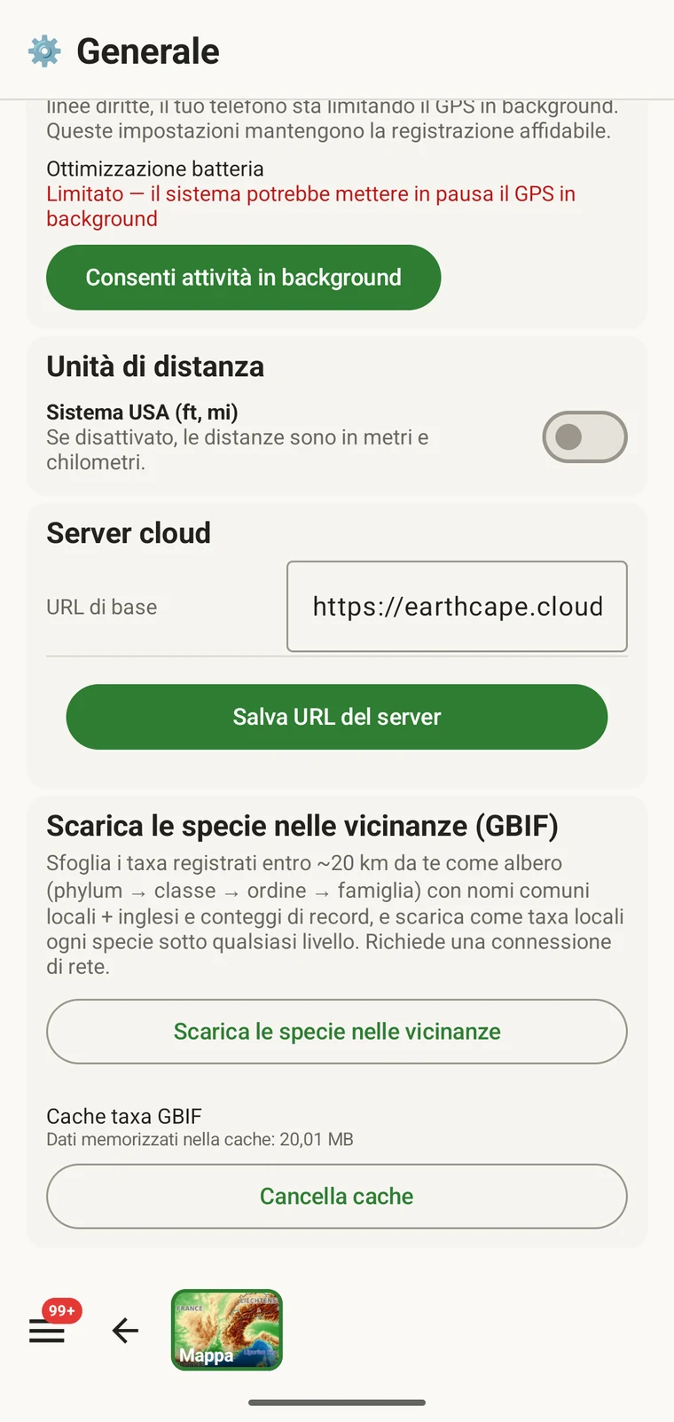
The entry point is the Download nearby species (GBIF) card under Menu → Admin → General; it is also offered during first-run setup. Scroll to the card and tap Download nearby species. The query runs against the live GBIF API, so you need a connection. Run it before you leave for the field, not once you have lost signal.
Che cosa restituisce l'interrogazione
The query looks at GBIF occurrence records within 20 km of your current position and groups them by phylum, giving for each phylum the number of distinct taxa at the chosen detail level (species by default). The sheet shows the top-level summary once Get data has run.
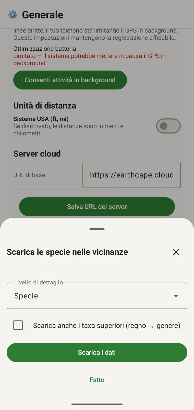
On opening, the sheet shows two controls and two buttons:
- Detail level (Phylum, Class, Order, Family or Species; Species is the default) — sets how far down the taxonomy the download goes when you tick a group.
- Also download parent taxa (kingdom → genus) checkbox — off by default; covered in its own section below.
- Get data — takes a GPS fix and loads the taxonomic tree for the area. Nothing is downloaded yet.
- Fatto — chiude il pannello.
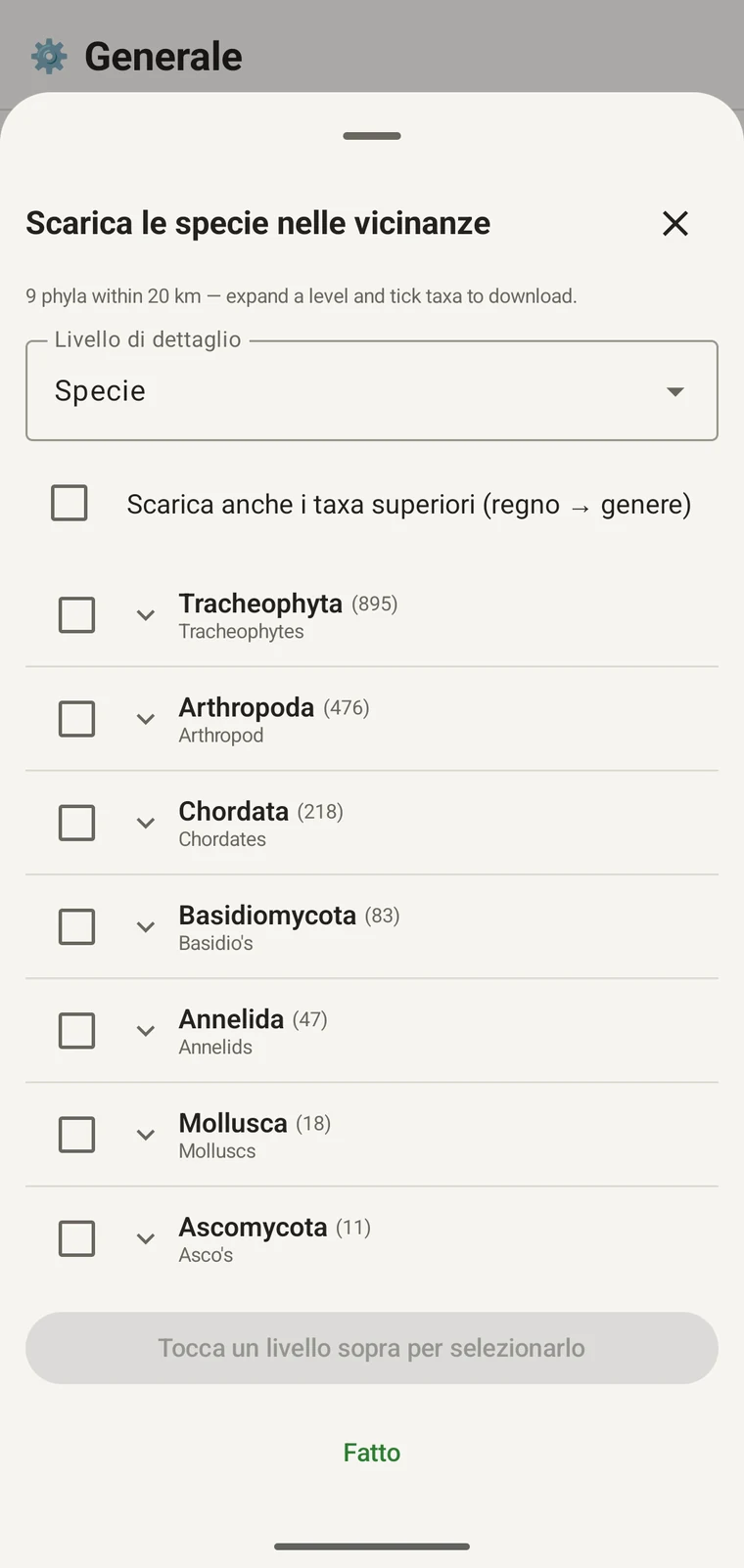
Once the tree has loaded the header reads, for example, "9 phyla within 20 km — expand a level and tick taxa to download.", a Select all row appears above the tree, and a Download N selected button replaces Get data.
L'esempio qui sotto proviene da un rilevamento in montagna. Il proprio sito restituirà i propri valori.
| Phylum | Species within 20 km |
|---|---|
| Tracheophyta | 895 |
| Arthropoda | 476 |
| Chordata | 218 |
| Basidiomycota | 83 |
| Annelida | 47 |
| Mollusca | 18 |
| Ascomycota | 11 |
Scendere di livello
Tap a phylum to expand it to its constituent classes, and tap a class to expand to orders. At each level the number in brackets is the count of distinct taxa at the chosen detail level recorded under that group within the search radius. A count shown as 1,000+ has hit the query cap.
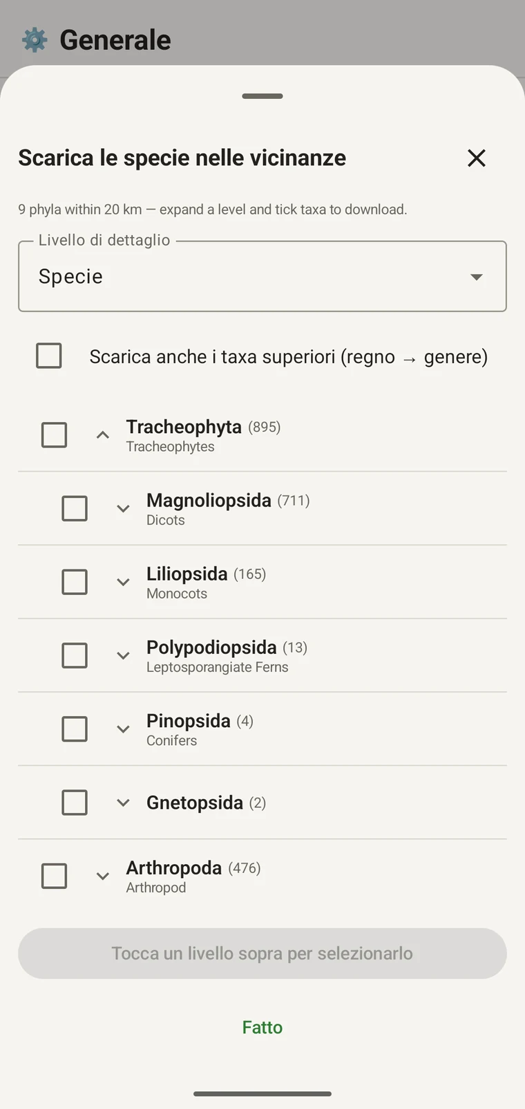
Proseguendo con lo stesso esempio: Tracheophyta si espande in Magnoliopsida 711, Liliopsida 165, Polypodiopsida 13, Pinopsida 4, Gnetopsida 2. L'espansione di Magnoliopsida dà Asterales 115, Lamiales 100, Fabales 93, Rosales 56, Caryophyllales 49, ciascuno mostrato con il proprio nome vernacolare.
The counts are numbers of distinct taxa in the published record, not record totals and not abundance estimates. A high count means many taxa in that group have been recorded and published for this area; a low count means the group is either genuinely species-poor here or simply under-surveyed and under-published. The distinction matters when you use the figures to plan work — see the section on survey planning below.
Livello di dettaglio e taxa superiori
The Detail level control sets the rank down to which taxa are downloaded when you tick a group. At Species, the download includes all species in GBIF's record for that group within the radius. If you are working at a coarser resolution — mapping genera only, for example — you can set the detail level to Family, Order, Class or Phylum to reduce the volume of names brought onto the device.
The Also download parent taxa (kingdom → genus) checkbox controls whether the higher ranks are fetched alongside the species. It is off by default; tick it in almost every case. Without it, the species names arrive on the device as orphans: the taxonomy held locally has no genus, family or order to attach them to, so they cannot be browsed by higher taxon and any rollup by group in your own data will not resolve correctly. Leave it off only if storage is genuinely tight and you intend to work entirely at species level with no hierarchical browsing.
Scaricare i taxa sul dispositivo
Nothing is pre-loaded onto the device for any particular site. The GBIF query populates the local taxonomy with GBIF Backbone names known to occur nearby, so when you record an observation you are picking from taxa that have actually been found at the site, rather than searching the full global list — and those names stay on the device once they are downloaded.
- Impostare il Livello di dettaglio sul rango che corrisponde alle proprie esigenze di registrazione. Specie è il valore predefinito.
- Tap Get data to load the tree for your position.
- Toccare un phylum per espanderlo, poi espandere ulteriormente fino alla classe o all'ordine desiderati.
- Spuntare la casella accanto a ciascun gruppo che si intende registrare. Si può spuntare a qualsiasi rango: spuntando una classe si scaricano tutti i taxa che la compongono fino al livello di dettaglio impostato.
- Tick Also download parent taxa unless storage is genuinely tight.
- Tap Download N selected. The app fetches the ticked taxa from GBIF and writes them to the local database in the background; a notification shows progress and you can close the sheet meanwhile.
- Toccare Fatto per chiudere il pannello.
I nomi scaricati sono poi ricercabili offline quando si inseriscono osservazioni, come descritto in Registrazione delle osservazioni. Si sceglie tra nomi noti localmente anziché digitarli a memoria dalla tassonomia globale completa.
Usarla per pianificare un rilevamento
Prima di una stagione sul campo, eseguire l'interrogazione sul sito previsto e leggere i conteggi a livello di phylum prima di scaricare qualsiasi cosa. La distribuzione dei conteggi indica quali gruppi sono ben rappresentati nel record pubblicato per quell'area e quali sono appena presenti.
A phylum with a handful of taxa is either genuinely absent from the site or under-surveyed and under-published there. Both cases are useful to know before a trip: genuine absence tells you where not to spend effort, and a thin published record for a group you expect to be present identifies a gap you can target.
Scaricare i taxa solo per i gruppi che si registreranno attivamente in una data uscita. Non c'è alcun vantaggio nel caricare sul dispositivo l'intero albero se si lavora su un solo phylum; lo scaricamento richiede tempo e banda di connessione di cui si potrebbe non disporre.
Limiti
L'interrogazione richiede una connessione attiva all'API di GBIF. Non può essere eseguita offline, ed è per questo che il flusso di lavoro previsto è eseguirla prima di lasciare un luogo connesso.
The search radius is 20 km around your current position. This is fixed by the query; there is no radius control in the app.
I conteggi riflettono ciò che è stato pubblicato su GBIF. La copertura è disomogenea tra le regioni e tra i gruppi tassonomici: i vertebrati dell'Europa occidentale sono di norma ben rappresentati; gli invertebrati e i funghi dell'Asia centrale non lo sono. Un conteggio basso è un'affermazione sul record pubblicato per quella combinazione di gruppo e luogo, non un'affermazione diretta sul sito. Interpretare i valori tenendolo presente.
Dall'app non si pubblica su GBIF. L'integrazione è di sola lettura: si interrogano i record esistenti e si scaricano nomi di taxa. Per contribuire con i propri dati a GBIF si esporta dall'app un file Darwin Core Archive o GBIF DwC-DP e lo si invia attraverso il canale GBIF standard — vedere Formati di esportazione per i formati di file disponibili.