
整合
GBIF 鄰近物種
The app queries the published GBIF occurrence record around your current position and returns the taxa that have been recorded there, arranged in a taxonomic tree you can expand level by level and download from. It shows which groups are represented, how many distinct species (or higher taxa, at the detail level you choose) each group holds in the published record, and which names belong to those groups, before you start your own recording.
開啟它
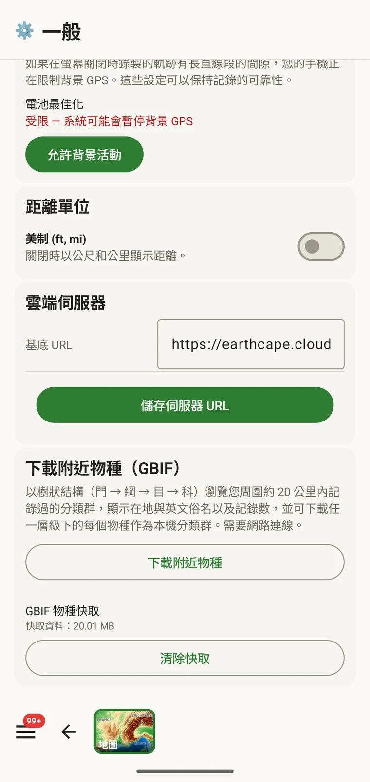
The entry point is the Download nearby species (GBIF) card under Menu → Admin → General; it is also offered during first-run setup. Scroll to the card and tap Download nearby species. The query runs against the live GBIF API, so you need a connection. Run it before you leave for the field, not once you have lost signal.
查詢會傳回什麼
The query looks at GBIF occurrence records within 20 km of your current position and groups them by phylum, giving for each phylum the number of distinct taxa at the chosen detail level (species by default). The sheet shows the top-level summary once Get data has run.
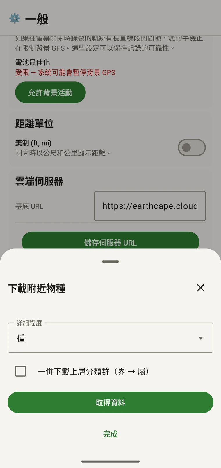
On opening, the sheet shows two controls and two buttons:
- Detail level (Phylum, Class, Order, Family or Species; Species is the default) — sets how far down the taxonomy the download goes when you tick a group.
- Also download parent taxa (kingdom → genus) checkbox — off by default; covered in its own section below.
- Get data — takes a GPS fix and loads the taxonomic tree for the area. Nothing is downloaded yet.
- 完成 — 關閉面板。
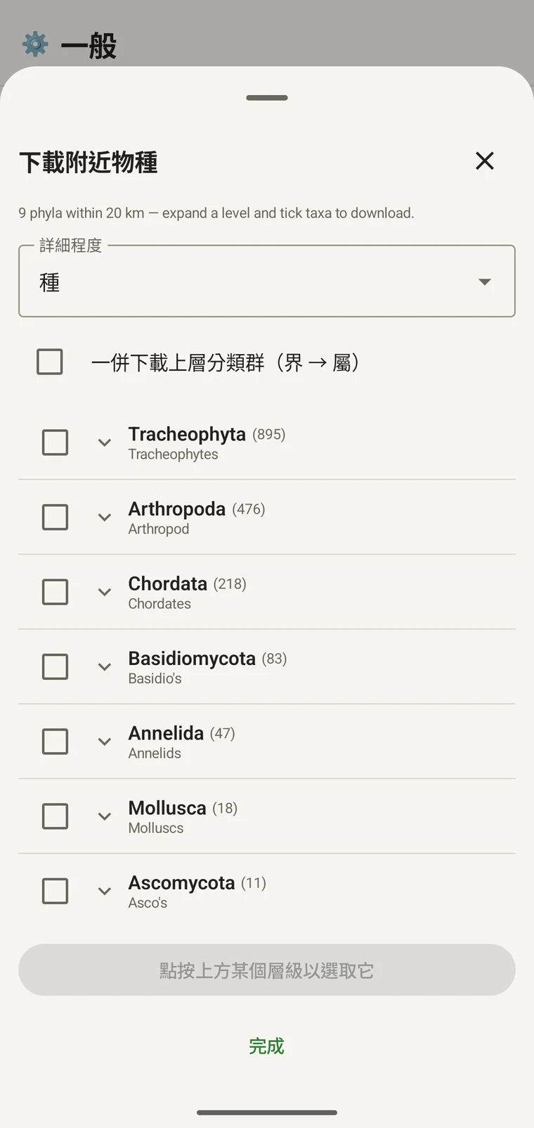
Once the tree has loaded the header reads, for example, "9 phyla within 20 km — expand a level and tick taxa to download.", a Select all row appears above the tree, and a Download N selected button replaces Get data.
下方的範例來自一次山區調查。您自己的樣點會傳回它自己的數字。
| 門 | Species within 20 km |
|---|---|
| Tracheophyta | 895 |
| Arthropoda | 476 |
| Chordata | 218 |
| Basidiomycota | 83 |
| Annelida | 47 |
| Mollusca | 18 |
| Ascomycota | 11 |
逐層展開
Tap a phylum to expand it to its constituent classes, and tap a class to expand to orders. At each level the number in brackets is the count of distinct taxa at the chosen detail level recorded under that group within the search radius. A count shown as 1,000+ has hit the query cap.
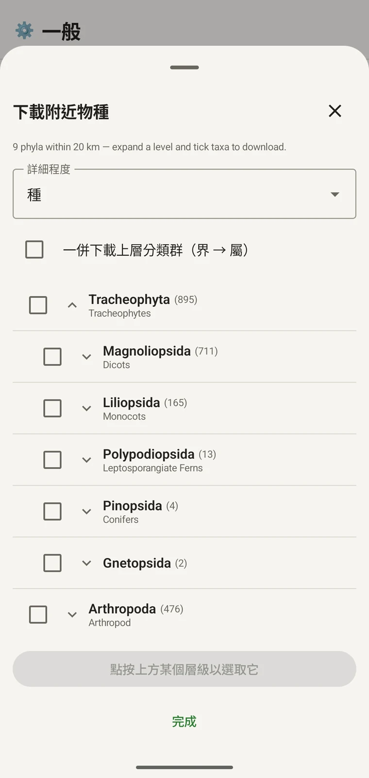
延續同一個範例:Tracheophyta 展開為 Magnoliopsida 711、Liliopsida 165、Polypodiopsida 13、Pinopsida 4、Gnetopsida 2。展開 Magnoliopsida 則得到 Asterales 115、Lamiales 100、Fabales 93、Rosales 56、Caryophyllales 49,每一項都附上它的俗名。
The counts are numbers of distinct taxa in the published record, not record totals and not abundance estimates. A high count means many taxa in that group have been recorded and published for this area; a low count means the group is either genuinely species-poor here or simply under-surveyed and under-published. The distinction matters when you use the figures to plan work — see the section on survey planning below.
詳細程度與上層分類群
The Detail level control sets the rank down to which taxa are downloaded when you tick a group. At Species, the download includes all species in GBIF's record for that group within the radius. If you are working at a coarser resolution — mapping genera only, for example — you can set the detail level to Family, Order, Class or Phylum to reduce the volume of names brought onto the device.
The Also download parent taxa (kingdom → genus) checkbox controls whether the higher ranks are fetched alongside the species. It is off by default; tick it in almost every case. Without it, the species names arrive on the device as orphans: the taxonomy held locally has no genus, family or order to attach them to, so they cannot be browsed by higher taxon and any rollup by group in your own data will not resolve correctly. Leave it off only if storage is genuinely tight and you intend to work entirely at species level with no hierarchical browsing.
將分類群下載到裝置
Nothing is pre-loaded onto the device for any particular site. The GBIF query populates the local taxonomy with GBIF Backbone names known to occur nearby, so when you record an observation you are picking from taxa that have actually been found at the site, rather than searching the full global list — and those names stay on the device once they are downloaded.
- 將詳細程度設為符合您記錄需求的階層。預設為種。
- Tap Get data to load the tree for your position.
- 點選一個門將它展開,再繼續展開到您要的綱或目。
- 勾選您將要記錄的每個類群旁的核取方塊。任何階層都可以勾選:勾選一個綱,會下載其下所有分類群,直到您設定的詳細程度為止。
- Tick Also download parent taxa unless storage is genuinely tight.
- Tap Download N selected. The app fetches the ticked taxa from GBIF and writes them to the local database in the background; a notification shows progress and you can close the sheet meanwhile.
- 點選完成關閉面板。
之後在記錄觀察中輸入觀察記錄時,已下載的名稱即可離線搜尋。您是從已知在當地出現的名稱中挑選,而不是憑記憶對著完整的全球分類系統輸入。
用它來規劃調查
在田野季開始前,先對您預定的樣點執行查詢,並在下載任何東西之前先讀門層級的計數。計數的分布會告訴您,哪些類群在該區域已發布的記錄中有充分呈現,哪些幾乎沒有。
A phylum with a handful of taxa is either genuinely absent from the site or under-surveyed and under-published there. Both cases are useful to know before a trip: genuine absence tells you where not to spend effort, and a thin published record for a group you expect to be present identifies a gap you can target.
只為您在該趟行程中會實際記錄的類群下載分類群。如果您只處理單一個門,把整棵樹載進裝置沒有任何好處;下載會耗費時間與連線頻寬,而這些您未必有。
限制
此查詢需要與 GBIF API 的即時連線。它無法離線執行,因此預期的工作流程是在您離開有連線的地點之前先執行它。
The search radius is 20 km around your current position. This is fixed by the query; there is no radius control in the app.
這些計數反映的是已發布到 GBIF 的內容。涵蓋程度在不同地區之間、不同分類群之間並不平均:西歐的脊椎動物通常有充分呈現,中亞的無脊椎動物與真菌則否。計數低,是對該類群與該地點這個組合的已發布記錄所做的陳述,而不是對該樣點本身的直接陳述。請帶著這一點解讀這些數字。
應用程式無法向 GBIF 發布資料。此整合是唯讀的:您查詢既有記錄並下載分類群名稱。若要把自己的資料貢獻給 GBIF,請從應用程式匯出 Darwin Core Archive 或 GBIF DwC-DP 檔案,再循 GBIF 的標準途徑提交;可用的檔案格式請見匯出格式。